
Michael Fish's NBC26 weather forecast
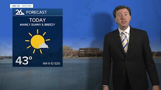
Today looks windy and seasonable with the sun coming back. Highs will be in the upper-50s to lower-60s. Those winds will be dying down tonight with chilly overnight lows in the low-30s thanks to mostly clear skies. It is looking more and more like the southern part of Wisconsin will get hit the hardest with this storm for the weekend. Basically, the farther you live to the south, the more you may be affected going from Saturday afternoon through Saturday night. This starts Saturday afternoon for some and ramps up into Saturday night. If you live well to the south, there may be a light accumulation mainly on the grass of only a trace of snow to up to 2" if this sneaks north. All it's going to take is a jaunt north of 50-100 miles to make a big difference for us. Lows will dip below freezing to the upper-20s. If there is a little accumulation here, most of it will melt on Sunday with some sunshine and highs around 50. There will be a chance of some cool rain on Monday with highs only in the 40s. The cooler temps will linger into early May.
-
 1:45
1:45
WGBA
1 year agoStudents excited to start at "huge and beautiful" Vel Phillips Middle School
306 -
 2:33
2:33
WGBA
4 years agoMichael Fish's NBC 26 weather forecast
4 -
 2:19
2:19
WGBA
4 years agoMichael Fish's NBC 26 weather forecast
3 -
 2:26
2:26
WGBA
4 years agoMichael Fish's NBC 26 weather forecast
4 -
 2:24
2:24
WGBA
4 years agoMichael Fish's NBC 26 weather forecast
3 -
 1:57
1:57
WGBA
4 years agoMichael Fish's NBC 26 weather forecast
2 -
 2:27
2:27
WGBA
4 years agoMichael Fish's NBC 26 weather forecast
4 -
 2:31
2:31
WGBA
4 years agoMichael Fish's NBC 26 weather forecast
7 -
 1:50
1:50
WGBA
4 years agoMichael Fish's NBC 26 weather forecast
4 -
 4:05
4:05
WGBA
3 years agoGino Recchia NBC26 Weather Forecast
1