Stunning aerials show large scale concrete map of Scotland
These stunning aerial pictures show a large scale 3D map of Scotland - the biggest one of its kind in the world. Polish war veteran Jan Tomasik devoted five years’ of work to building the concrete model, between 1974 and 1979, which is currently being restored by volunteers. Built in the grounds of a hotel once owned by Mr Tomasik, the Great Polish Map of Scotland is the largest physical three-dimensional map of a country in the world, covering an area of 1,590 square metres. The hotelier served in the Second World War, and met his Scottish wife when she cared for him in a hospital. Mr Tomasik settled in Edinburgh when the war ended, and commissioned the massive map as a gift to the Scottish people, in the grounds of a hotel he owned in the Borders.
-
 1:12
1:12
SWNS
2 days agoHalf of Americans concerned about climate change devastation
30 -
 2:19
2:19
galwaycinematography
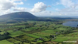
2 years agoStunning drone footage captures beautiful Irish countryside
2.38K20 -
 4:02
4:02
Dany4018
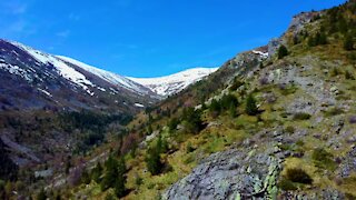
3 years agoStunning drone footage of Pelister National Park in Macedonia
1.83K -
 2:44
2:44
haanity
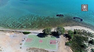
3 years agoDrone captures exotic Greek basketball court with stunning views
10.6K5 -
 3:09
3:09
TimelessAerialPhotography
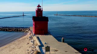
3 years ago $0.75 earnedStunning winter drone footage of Holland Harbor Lighthouse in Michigan
1.05K2 -
 13:53
13:53
Hardwick68
3 years agoLarge & Small Scale Collection
12 -
 0:07
0:07
KTNV
2 years agoWorld of Concrete making first large show return at Las Vegas Convention Center
9 -
 4:10
4:10
NEWSMAX
2 years agoHAITI MIGRANTS FREED ON A "VERY, VERY LARGE SCALE"
3.89K58 -
 10:48
10:48
Fascinating Horror
1 day agoA Brief History of Death by Selfie | Fascinating Horror
11.5K8 -
 6:45
6:45
ErmzPlays
20 hours agoThe Helldivers 2 Player Count is FREEFALLING
11K3