NBC26 Storm Shield weather forecast
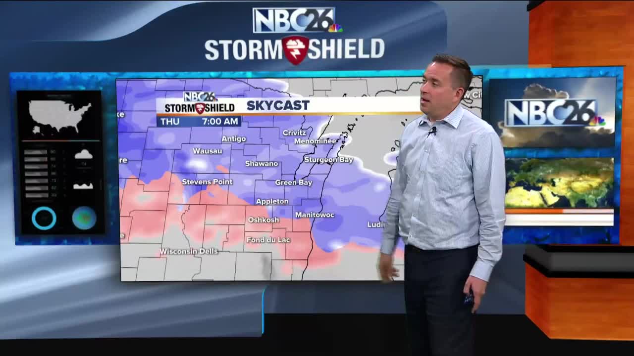
It seems like we are having all the seasons of the year in one week. Monday, we had a taste of Summer with highs in the upper 60s and lower 70s. Yesterday it felt more like an early spring or late fall day. Today we will feel like it’s closer to winter, especially later tonight. By now you have probably heard snow is on the way. It is holding off until later tonight so anything during the first half of your day will be uninterrupted by Mother Nature. It will be cool though as temperatures will only rise to near 40 degrees with cloudy skies and winds blowing in from the northeast around 10 to 20 mph with gusts near 25 mph. Tonight, the snow returns to Northeast Wisconsin. A band of moderate snow will begin to move in from the southern part of the state and gradually lift northward throughout the whole area. Initially temperatures will be above freezing but as we go into the overnight period, we will see temperatures drop down into the lower 30s and possibly the upper 20s. Winds will be picking up out of the northeast around 15 to 25 mph with gusts near 45 mph. By Daybreak, snowfall totals should be around 3 to 6 inches areawide. Temperatures will begin to climb above freezing changing any lingering snow over to a wintry mix and then to rainfall by the afternoon. Some additional snow will fall however in the Northwoods where 6 to 10 inch totals will accumulate. Temperatures rise into the upper 30s Thursday evening with strong winds out of the northeast at 25 to 30 mph with gusts up to 50 mph. Showers and thunderstorms will develop in the afternoon. The storm system begins to break down Friday with a few light rain showers on and off through the day. Temperatures rise into the lower 40s. Saturday will be mostly cloudy with temperatures in the lower 40s with a stray shot of rain showers, especially in the Northwoods.
-
 0:30
0:30
WGBA
1 year agoThree Degree Guarantee
244 -
 4:05
4:05
WGBA
3 years agoGino Recchia NBC26 Weather Forecast
1 -
 2:30
2:30
WGBA
3 years agoGino Recchia NBC26 Weather Forecast
71 -
 3:34
3:34
WGBA
3 years agoGino Recchia NBC26 Weather Forecast
6 -
 2:57
2:57
WGBA
3 years agoGino Recchia NBC26 Weather Forecast
1 -
 3:30
3:30
WGBA
3 years agoGino Recchia NBC26 Weather Forecast
12 -
 2:55
2:55
WGBA
3 years agoGino Recchia NBC26 Weather Forecast
5 -
 3:22
3:22
WGBA
3 years agoGino Recchia NBC26 Weather Forecast
-
 3:24
3:24
WGBA
3 years agoGino Recchia NBC26 Weather Forecast
2 -
 2:53
2:53
WGBA
3 years agoGino Recchia NBC26 Weather Forecast
1