NBC26 Storm Shield weather forecast
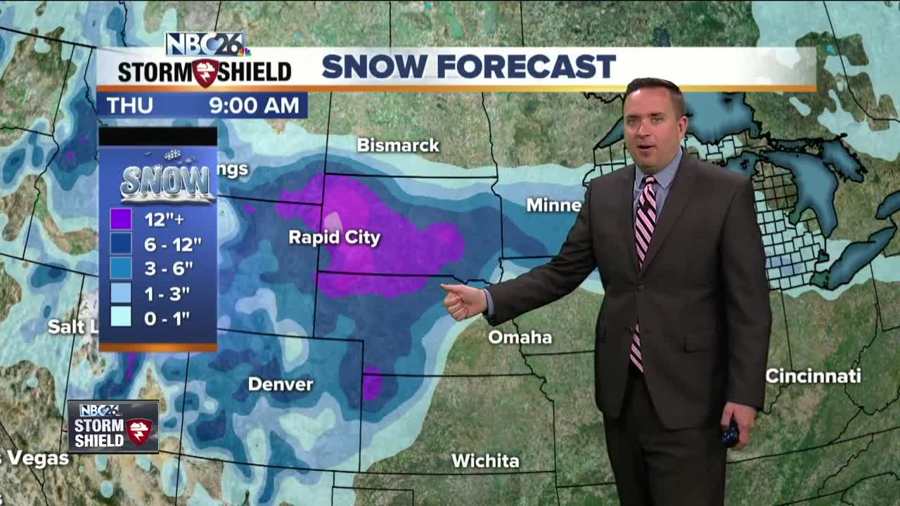
The potential for a winter storm across the Midwest is turning more and more likely as we get closer to the event. We still have almost 36 hours to go before it gets here, so the forecast will likely change as it gets closer. Right now it appears that most of Wednesday will be dry with snow developing late in the day. The main brunt of the storm looks like it will start on Wednesday night as snow becomes more widespread & heavy. By the time you wake up on Thursday, there looks like a fairly good likelihood that we'll have a decent amount of snow on the ground. It will be heavy, wet snow. This will continue into the first half of Thursday. As a warm front lifts through the whole area, the snow could turn over to a mix of sleet, freezing rain, rain and snow with temperatures remaining in the low/mid 30s. This mix will change back over to some snow as Thursday night progresses. Strong NE winds will gust 40-50 mph. Measuring this snow could be quite tricky as the snow will be melting from the bottom with the mild ground, and from the top with the above freezing temps and possible mix falling on top. There could be quite a bit of snow, that falls out of this, especially north, but as of this moment, it does NOT look as big as last April's blizzard. This is my (Michael Fish) first stab at the snow totals through Friday with the bulk of this falling Wednesday night into Thursday. Green Bay and the Fox Cities may see 3-6" by the end of this with the lower totals south. Around and north of Highway 29 looks like they could get 6-10" as this will stay as snow longer. On Friday, the storm will begin to push out of the area with wrap around snow showers and temperatures once again in 30s to around 40°. Temperatures will stay in the 30s & 40s over the weekend. There is the for some more snow Sunday evening.....stay tuned.
-
 1:45
1:45
WGBA
2 years agoStudents excited to start at "huge and beautiful" Vel Phillips Middle School
388 -
 4:05
4:05
WGBA
3 years agoGino Recchia NBC26 Weather Forecast
1 -
 2:30
2:30
WGBA
3 years agoGino Recchia NBC26 Weather Forecast
71 -
 3:34
3:34
WGBA
3 years agoGino Recchia NBC26 Weather Forecast
6 -
 2:57
2:57
WGBA
3 years agoGino Recchia NBC26 Weather Forecast
1 -
 3:30
3:30
WGBA
3 years agoGino Recchia NBC26 Weather Forecast
14 -
 2:55
2:55
WGBA
3 years agoGino Recchia NBC26 Weather Forecast
5 -
 3:22
3:22
WGBA
3 years agoGino Recchia NBC26 Weather Forecast
2 -
 3:24
3:24
WGBA
4 years agoGino Recchia NBC26 Weather Forecast
2 -
 2:53
2:53
WGBA
3 years agoGino Recchia NBC26 Weather Forecast
1