Gino Recchia NBC26 Storm Shield Weather Forecast
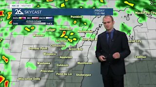
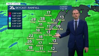
A winter weather advisory has been issued for areas north of Highway 10 for accumulating snowfall starting Saturday afternoon and lasting through Sunday morning. Tonight still will be quiet with clouds on the increase ahead of our next system. Lows will be in the upper-teens. Winds will be light out of the southeast between 2 to 5 mph. The system for the weekend is still developing over the Rockies, so there still could be a few tweaks to the forecast as it approaches. Either way, Saturday morning starts off okay, but thing will slowly go downhill in the afternoon as a mix of snow and possibly rain starts to roll in. It will become windy between 15 to 25 mph with gusts up to 35 mph out of the northeast. Highs will be in the mid-30s. The main brunt of this system will impact the area on Saturday night with snow or a little wintry mix rolling through. Basically the farther you live to the north, the more snow you may see out of this. Through the night, 3-6" may fall from Green Bay north with the higher totals north. A few localized areas could get 7 inches. South of Green Bay, accumulations will be between 1 to 3 inches by the time the system moves out of the area. A few snow showers will persist Sunday as the storm lifts out of the area. It will still be breezy but high temperatures will manage to rise into the mid 30s once again. The sun comes back out Monday with breezy and cooler highs around 30. Then we gradually warm up into the lower-40s by Wednesday but it does come with a risk of some light rainfall.
-
 0:30
0:30
WGBA
9 months agoThree Degree Guarantee
120 -
 3:24
3:24
WGBA
2 years agoGino Recchia NBC26 Weather Forecast
2 -
 3:54
3:54
WGBA
2 years agoGino Recchia NBC26 Weather Forecast
2 -
 2:46
2:46
WGBA
2 years agoGino Recchia NBC26 Weather Forecast
2 -
 3:11
3:11
WGBA
2 years agoGino Recchia NBC26 Weather Forecast
2 -
 3:14
3:14
WGBA
2 years agoGino Recchia NBC26 Weather Forecast
8 -
 2:52
2:52
WGBA
2 years agoGino Recchia NBC26 Weather Forecast
5 -
 3:01
3:01
WGBA
2 years agoGino Recchia NBC26 Weather Forecast
5 -
 2:54
2:54
WGBA
2 years agoGino Recchia NBC26 Weather Forecast
3 -
 2:41
2:41
WGBA
2 years agoGino Recchia NBC26 Weather Forecast
2