Michael Fish's NBC26 Storm Shield weather forecast
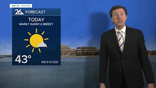
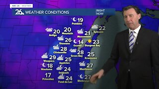
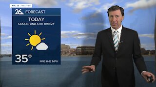
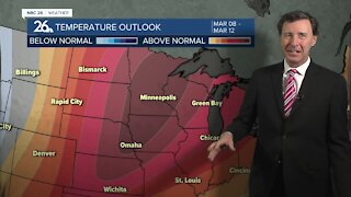
Today won't be as cold with highs in the low-30s in the afternoon. Winds will be out of the southwest around 4 to 8 mph with mostly cloudy skies. Average highs tomorrow run in the mid-30s so we will still be slightly below normal. Tonight still will be quiet with clouds on the increase ahead of our next system. Lows will be in the upper-teens. The system for the weekend is still developing over the Rockies, so there still could be a few tweaks to the forecast as it approaches. Either way, Saturday morning starts off okay, but thing will slowly go downhill in the afternoon as a mix of snow and possibly rain starts to roll in. There could be some minor accumulation by the evening. It will become windy with highs in the mid-30s. The main brunt of this system will impact the area on Saturday night with snow or a little wintry mix rolling through. Basically the farther you live to the north, the more snow you may see out of this. Through the night, 3-5" may fall from Green Bay north with the higher totals north, and 1-2" for Appleton and the Fox Cities. Even lesser amounts farther south. Most of this system will be moving out on Sunday morning with another Tr-1". That would bring potential snow totals from 3-5" Green Bay and north with the higher totals north, and 1-3" for Appleton and the Fox Cities. Even lesser amounts farther south. It will be windy, though we'll do some melting with highs in the upper 30s. The sun comes back out Monday with breezy and cooler highs around 30. Then we gradually warm up into the lower-40s by Wednesday but it does come with a risk of some light rainfall or possible early light snowfall.
-
 0:30
0:30
WGBA
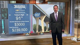
11 months agoThree Degree Guarantee
171 -
 2:33
2:33
WGBA
3 years agoMichael Fish's NBC 26 weather forecast
4 -
 2:19
2:19
WGBA
3 years agoMichael Fish's NBC 26 weather forecast
3 -
 2:26
2:26
WGBA
3 years agoMichael Fish's NBC 26 weather forecast
4 -
 2:24
2:24
WGBA
3 years agoMichael Fish's NBC 26 weather forecast
3 -
 2:27
2:27
WGBA
3 years agoMichael Fish's NBC 26 weather forecast
4 -
 1:57
1:57
WGBA
3 years agoMichael Fish's NBC 26 weather forecast
2 -
 2:31
2:31
WGBA
3 years agoMichael Fish's NBC 26 weather forecast
7 -
 1:50
1:50
WGBA
3 years agoMichael Fish's NBC 26 weather forecast
4 -
 2:27
2:27
WGBA
3 years agoMichael Fish's NBC 26 weather forecast
1