NBC26 Storm Shield weather forecast
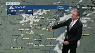
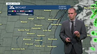
This will be the snowiest February in 129 years!! Tonight into Wednesday morning will be the main brunt of this system. This will cause some headaches for the Wednesday morning commute especially. Accumulations at this time look to be between 4-7". Luckily, it won't be as windy as this past weekend's storm, so blowing and drifting won't be much of an issue. Highs Wednesday will be in the low/mid-20s for cleanup. Cold weather will persist on Thursday with a mix of clouds & sun. March will come in like a lion with the combination of cold temps & more snow. Snow will return to the area by Friday evening & continue into Saturday with several inches possible. FRIGID air moves back in this weekend, especially Sunday. This cold air mass persists into next week and really has no end in the next week or more. If you want spring weather on March 1st, good luck finding that in Northeast Wisconsin. At this rate, perhaps staying in Florida for the time being might be a safer bet.
-
 1:45
1:45
WGBA
7 months agoStudents excited to start at "huge and beautiful" Vel Phillips Middle School
53 -
 2:54
2:54
WGBA
2 years agoGino Recchia NBC26 Weather Forecast
3 -
 2:41
2:41
WGBA
2 years agoGino Recchia NBC26 Weather Forecast
2 -
 3:33
3:33
WGBA
2 years agoGino Recchia NBC26 Weather Forecast
6 -
 3:07
3:07
WGBA
2 years agoGino Recchia NBC26 Weather Forecast
3 -
 3:58
3:58
WGBA
2 years agoGino Recchia NBC26 Weather Forecast
5 -
 2:56
2:56
WGBA
2 years agoGino Recchia NBC26 Weather Forecast
5 -
 4:13
4:13
WGBA
2 years agoGino Recchia NBC26 Weather Forecast
31 -
 4:13
4:13
WGBA
2 years agoGino Recchia NBC26 Weather Forecast
41 -
 2:53
2:53
WGBA
2 years agoGino Recchia NBC26 Weather Forecast
2