Gino Recchia NBC26 Storm Shield Weather Forecast
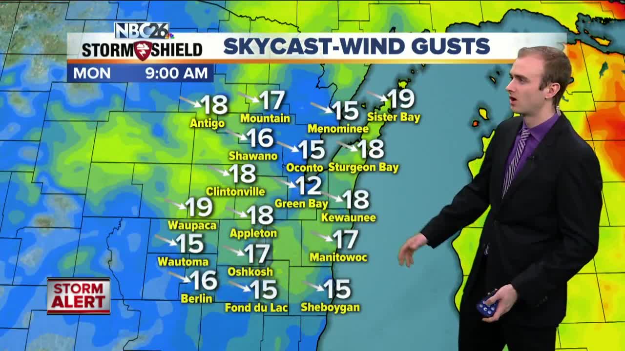
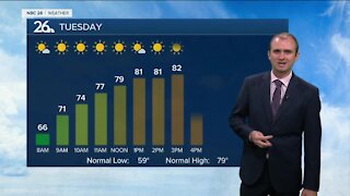
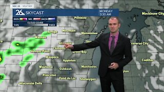
Blizzard Warnings and Winter Storm Warnings remain in place this evening for areas northwest of the Fox Valley with a high wind warning for everyone else. Snowfall did come to an end but the fresh snowfall is causing some substantial blowing and drifting resulting in periodic whiteout conditions away from urban areas. Highest wind gusts reached between 50 and 60 mph. Sustained winds will begin to diminish overnight from 25 mph to 15 mph by daybreak tomorrow out of the northwest. With temperatures dipping down below zero, wind chills will be between -20 and -30 degrees so make sure to dress extra warm as you head out the door. High temperatures will rise to near 10 Monday with partly cloudy skies. Temperatures drop slightly below zero Tuesday morning with mostly cloudy skies in the afternoon and a high around 11. Late Tuesday night into Wednesday our next snow system will move through. This will cause some headaches for the morning commute and the evening commute. Accumulations at this time look to be between 3 and 6 inches with some data suggesting localized areas getting 7 inches of snow. If this forecast holds, February will end as the 3rd snowiest on record in Green Bay. Dry weather Thursday and Friday with highs in the lower to mid 20s followed by another round of snow Saturday with a couple inches possible. If you want spring weather March 1st, good luck finding that in Northeast Wisconsin. At this rate, perhaps staying in Florida until May might be a safer bet.
-
 1:57
1:57
WGBA
1 year agoHow the City of Green Bay is hoping a $1.6M investment will make the community safer for pedestrians
4482 -
 2:54
2:54
WGBA
3 years agoGino Recchia NBC26 Weather Forecast
3 -
 2:41
2:41
WGBA
3 years agoGino Recchia NBC26 Weather Forecast
2 -
 3:33
3:33
WGBA
3 years agoGino Recchia NBC26 Weather Forecast
6 -
 3:07
3:07
WGBA
3 years agoGino Recchia NBC26 Weather Forecast
3 -
 3:58
3:58
WGBA
3 years agoGino Recchia NBC26 Weather Forecast
5 -
 2:56
2:56
WGBA
3 years agoGino Recchia NBC26 Weather Forecast
5 -
 2:53
2:53
WGBA
3 years agoGino Recchia NBC26 Weather Forecast
2 -
 0:58
0:58
WGBA
3 years agoGino Recchia NBC26 Weather Forecast
9 -
 3:37
3:37
WGBA
3 years agoGino Recchia NBC26 Weather Forecast
1