Gino Recchia NBC26 Storm Shield Weather Forecast
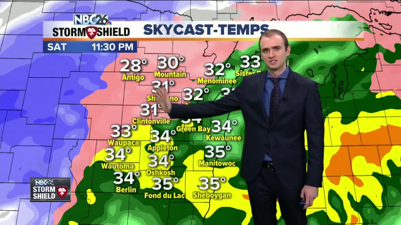
It is a very busy and messy weekend in Wisconsin thanks to a strong winter storm moving through the Badger State. We had the first initial round of precipitation this morning consisting from snow, to sleet, freezing rain, and rain. Some radar estimates show over an inch fell in Fond Du Lac County. There is a flood advisory until midnight tonight for Marquette, Green Lake, Fond Du Lac, and Sheboygan counties. The recent rainfall coupled with ice and snow blocking some drains is causing ponding water. The next round of precipitation is moving in tonight from the south. With the center of low pressure tracking through Southern Wisconsin, only parts of the viewing area will see snowfall, while others see a wintry mix. Winter storm warnings are in effect from Waupaca, Shawano, Menominee, Langlade, and northern parts of Oconto, and Marinette County until Sunday afternoon. Winter weather advisories are in effect for southern parts of Oconto and Marinette County. Those locations will have a combination of sleet, snow, and freezing rain. Ice accumulations up to a quarter inch is possible for many locations with possible higher totals locally. Snowfall totals will be higher farther to the Northwoods or to Wausau you live. There will be a sharp snow accumulation gradient with totals only between a dusting to an inch for areas along the Fox Valley and to Lake Michigan. Northwest of the valley, snow accumulations will go from 1 inch from Green Bay to as high as 10 inches in Northwestern Langlade County. Any wintry mix will transition to snow Sunday morning as cold air wraps around this departing storm. Temperatures will be dropping throughout the day departing this storm. Winds will also be increasing rapidly out of the west with gusts up to 50 mph at times. This will drop wind chills to the single digits tomorrow afternoon and evening. Winds Chills by Monday morning will be in the -20's. Temperature highs will only rise into the single digits which is more than 20 degrees below normal. Sorry to be blunt....but spring weather is not coming anytime soon.
-
 3:36
3:36
WGBA
1 year agoWill it be necessary to have both the AC & the heat on during the same day??
3811 -
 2:54
2:54
WGBA
3 years agoGino Recchia NBC26 Weather Forecast
3 -
 2:41
2:41
WGBA
3 years agoGino Recchia NBC26 Weather Forecast
2 -
 3:33
3:33
WGBA
3 years agoGino Recchia NBC26 Weather Forecast
6 -
 3:07
3:07
WGBA
3 years agoGino Recchia NBC26 Weather Forecast
3 -
 3:58
3:58
WGBA
3 years agoGino Recchia NBC26 Weather Forecast
5 -
 2:56
2:56
WGBA
3 years agoGino Recchia NBC26 Weather Forecast
5 -
 2:53
2:53
WGBA
3 years agoGino Recchia NBC26 Weather Forecast
2 -
 0:58
0:58
WGBA
3 years agoGino Recchia NBC26 Weather Forecast
9 -
 3:37
3:37
WGBA
3 years agoGino Recchia NBC26 Weather Forecast
1