NBC26 Storm Shield weather forecast
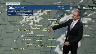
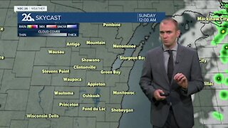
High pressure will build into Wisconsin later tonight & control our weather through Friday. Dry weather returns Thursday and Friday with high temps mainly in the low- to mid-30s.....above normal for this time of year. This upcoming weekend there is the potential for some more snow/mix/rain on Saturday into Saturday night, before changing over to mostly snow on Sunday. It's too early to make the exact call on any snowfall amounts, but this storm has the potential to be a big one across parts of the area( especially NW of the Fox Valley). Stay tuned. This February will be one of the snowiest or "the snowiest" on record when all is said & done with the potential for more snow next week. The month looks to end on a very cold note!! Temps will be running 15-25° below normal as we head into March!! Roar!!!
-
 1:45
1:45
WGBA
7 months agoFond du Lac Cardinals start the football season with a new $5.3 million nest
63 -
 2:54
2:54
WGBA
2 years agoGino Recchia NBC26 Weather Forecast
3 -
 2:41
2:41
WGBA
2 years agoGino Recchia NBC26 Weather Forecast
2 -
 3:33
3:33
WGBA
2 years agoGino Recchia NBC26 Weather Forecast
6 -
 3:07
3:07
WGBA
2 years agoGino Recchia NBC26 Weather Forecast
3 -
 2:56
2:56
WGBA
2 years agoGino Recchia NBC26 Weather Forecast
5 -
 4:13
4:13
WGBA
2 years agoGino Recchia NBC26 Weather Forecast
31 -
 4:13
4:13
WGBA
2 years agoGino Recchia NBC26 Weather Forecast
41 -
 2:53
2:53
WGBA
2 years agoGino Recchia NBC26 Weather Forecast
2 -
 0:58
0:58
WGBA
2 years agoGino Recchia NBC26 Weather Forecast
9