NBC26 Storm Shield weather forecast
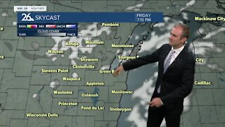
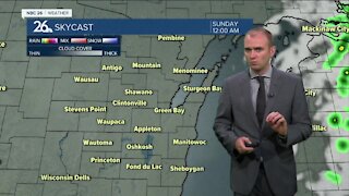
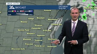
After a stretch of colder & mainly quiet weather....it's about to active again. Snow is on the way for Wednesday. It will develop in the early morning and last through the day. Highs will be in the low-30s and it will be quite breezy. Most areas will see 3-6" of snow by evening. It won't be one of the heaviest snows we've seen, but it won't be just a little nuisance either. Dry weather returns Thursday and Friday with temps in the low- to mid-30s. This upcoming weekend there is the potential for some more snow/mix/rain on Saturday going over to all snow on Sunday. It's way too early to make the call on any amounts but this storm has the potential to be a big one across parts of the area. Stay tuned. It's looking more & more like this will be the snowiest February on record with the potential of more snow next week.
-
 0:30
0:30
WGBA
1 year agoThree Degree Guarantee
188 -
 2:54
2:54
WGBA
3 years agoGino Recchia NBC26 Weather Forecast
3 -
 2:41
2:41
WGBA
3 years agoGino Recchia NBC26 Weather Forecast
2 -
 3:33
3:33
WGBA
3 years agoGino Recchia NBC26 Weather Forecast
6 -
 3:07
3:07
WGBA
3 years agoGino Recchia NBC26 Weather Forecast
3 -
 2:56
2:56
WGBA
3 years agoGino Recchia NBC26 Weather Forecast
5 -
 4:13
4:13
WGBA
3 years agoGino Recchia NBC26 Weather Forecast
31 -
 4:13
4:13
WGBA
3 years agoGino Recchia NBC26 Weather Forecast
41 -
 2:53
2:53
WGBA
3 years agoGino Recchia NBC26 Weather Forecast
2 -
 0:58
0:58
WGBA
3 years agoGino Recchia NBC26 Weather Forecast
9