NBC26 Storm Shield weather forecast
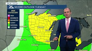
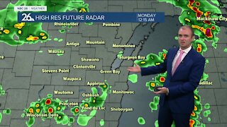
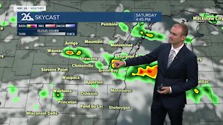
Our active weather continues!! A strong area of low pressure system will impact the area tonight & tomorrow!! A patchy light mix will move in overnight. The main brunt of this storm will be on Thursday PM where Green Bay and the Fox Cities will see areas of snow, sleet and freezing rain at times. As of now, it looks like snow and sleet accumulations (across the Fox Valley)will be between 1-6"(less south - more north), but icing could be a problem in spots. Northwest of the Fox Valley, you could see 6-12"+. Because of all this potential mess, a Winter Storm Warning will go into effect at 12 AM Thursday and continue into Thursday night. Our far southern counties will have a Winter Weather Advisory starting tonight and lasting through Thursday. Traveling will be hazardous. Blowing & drifting snow is likely. Icing may produce power outages!! It gets cold and blustery Thursday night as the precipitation moves out. Lows will be in the low-single digits. Wind chills Friday morning will be in the -10s & -20s. Get ready for a cold, blustery day on Friday with highs in the upper-single digits with wind chills below zero. Saturday will be dry but then we'll have another chance of a little snow on Sunday. Temperatures over the next 7 days are generally going to be below average but there is no MAJOR arctic blast in the foreseeable future at least.
-
 1:45
1:45
WGBA
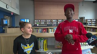
9 months agoStudents excited to start at "huge and beautiful" Vel Phillips Middle School
146 -
 4:13
4:13
WGBA
2 years agoGino Recchia NBC26 Weather Forecast
31 -
 4:13
4:13
WGBA
2 years agoGino Recchia NBC26 Weather Forecast
41 -
 3:36
3:36
WGBA
2 years agoGino Recchia NBC26 Weather Forecast
10 -
 3:29
3:29
WGBA
2 years agoGino Recchia NBC26 Weather Forecast
12 -
 4:09
4:09
WGBA
2 years agoGino Recchia NBC26 Weather Forecast
11 -
 3:46
3:46
WGBA
2 years agoGino Recchia NBC26 Weather Forecast
13 -
 3:32
3:32
WGBA
2 years agoGino Recchia NBC26 Weather Forecast
17 -
 3:28
3:28
WGBA
2 years agoGino Recchia NBC26 Weather Forecast
11 -
 2:33
2:33
WGBA
2 years agoGino Recchia NBC26 Weather Forecast
15