Gino Recchia NBC26 Storm Shield Weather Forecast
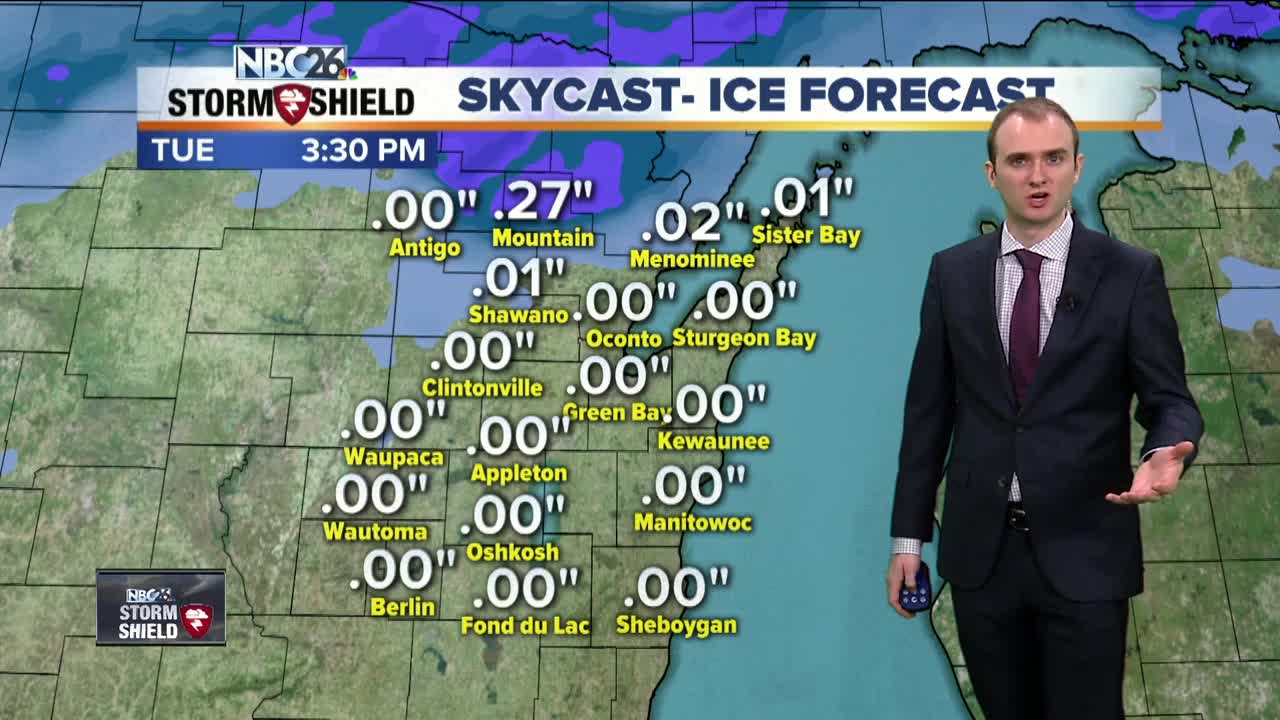
Dense fog advisories have been issued for the area this morning and last through tonight due to this mild air mass traveling over a cold snowpack. Visibility has dropped to a quart of a mile and less this evening resulting in hazardous travel conditions. There is also an ice storm warnning in effect for northern Marinette County and Menominee County for the threat of freezing rain tomorrow. A low pressure is developing over the Central Plains and will make its way into the Midwest Monday bringing rainfall for most of the area. The exception is farther to the Northwoods where enough cold air near the surface will result in a freezing rain problem. Ice accumulation could get upwards of a quarter inch. Precipitation will fall overnight and end by the late morning .Temperatures will be falling in the late afternoon as cold air fills in behind this storm system. Highs on Tuesday will be back in the upper teens after Mondays highs in the mid 40s south of Highway 29, and lower to upper 30s north of Highway 29. The next chance of snow moves in late Tuesday night into Wednesday morning. A couple inches of snow currently is projected. Soon after, another system moves in Thursday evening into Friday morning. This could be a stronger storm resulting in over a half foot of snow if it materializes correctly. Saturday will be dry but then another round of snow moves in Sunday which will bring perhaps an additional few inches. Temperatures over the next 7 days are generally going to be below average but there is no arctic blast in the foreseeable future at least.
-
 1:57
1:57
WGBA
1 year agoHow the City of Green Bay is hoping a $1.6M investment will make the community safer for pedestrians
3051 -
 4:13
4:13
WGBA
3 years agoGino Recchia NBC26 Weather Forecast
41 -
 3:29
3:29
WGBA
3 years agoGino Recchia NBC26 Weather Forecast
12 -
 3:36
3:36
WGBA
3 years agoGino Recchia NBC26 Weather Forecast
10 -
 4:09
4:09
WGBA
3 years agoGino Recchia NBC26 Weather Forecast
11 -
 3:28
3:28
WGBA
3 years agoGino Recchia NBC26 Weather Forecast
11 -
 3:21
3:21
WGBA
3 years agoGino Recchia NBC26 Weather Forecast
8 -
 2:33
2:33
WGBA
3 years agoGino Recchia NBC26 Weather Forecast
15 -
 3:46
3:46
WGBA
3 years agoGino Recchia NBC26 Weather Forecast
13 -
 3:32
3:32
WGBA
3 years agoGino Recchia NBC26 Weather Forecast
17