Michael Fish's NBC26 Storm Shield weather forecast
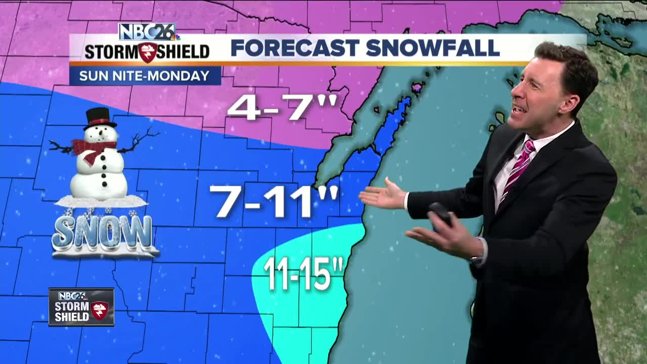
We'll have a cold and quiet night and quiet day on Sunday before things really go downhill on Sunday night into Monday when a Winter Storm Warning goes into effect for most of the NBC26 viewing area. Tonight, we'll have a chance of a few flurries and cold wind chills again from -15 to -30. Sunday during the day will be cold, but dry with morning wind chills from -15 to -30. Clouds will be on the increase ahead of the next system for the nighttime. We have abnormally strong clipper system that's going to pass by the state on Sunday night going through Monday. Because of the cold air and wind direction coming off of Lake Michigan, there will be some areas to the SE near the lake that will have some lake enhanced totals. Snow will start to develop as we head into the mid-evening and pick up in intensity through the night. The wind will really start to pick up and shift to the NE, off of Lake Michigan. By morning, we could have 4-8" of snow with blowing and drifting as well. The highest totals will be to the SE near Lake Michigan with that lake enhancement. The snow and blowing snow will continue through Monday. The snow will be heavy at times. Another 3-7" will fall with the highest totals to the SE near that lake enhanced area. This will bring general totals from 7-11", but where lake enhancement occurs to the SE, we could end up with over 12" in spots there. Lesser totals will fall to the far north. Most of the system should be out of here going into Monday night. A bitterly cold blast of air will move in behind that system that could last until next weekend. We will have dangerous wind chills on Wednesday and Thursday mornings like we haven't seen so far this winter.
-
 0:30
0:30
WGBA
2 years agoThree Degree Guarantee
371 -
 2:33
2:33
WGBA
4 years agoMichael Fish's NBC 26 weather forecast
4 -
 2:19
2:19
WGBA
4 years agoMichael Fish's NBC 26 weather forecast
3 -
 2:26
2:26
WGBA
4 years agoMichael Fish's NBC 26 weather forecast
4 -
 2:24
2:24
WGBA
4 years agoMichael Fish's NBC 26 weather forecast
3 -
 2:27
2:27
WGBA
4 years agoMichael Fish's NBC 26 weather forecast
4 -
 1:57
1:57
WGBA
4 years agoMichael Fish's NBC 26 weather forecast
2 -
 2:31
2:31
WGBA
4 years agoMichael Fish's NBC 26 weather forecast
7 -
 1:50
1:50
WGBA
4 years agoMichael Fish's NBC 26 weather forecast
4 -
 2:27
2:27
WGBA
4 years agoMichael Fish's NBC 26 weather forecast
1