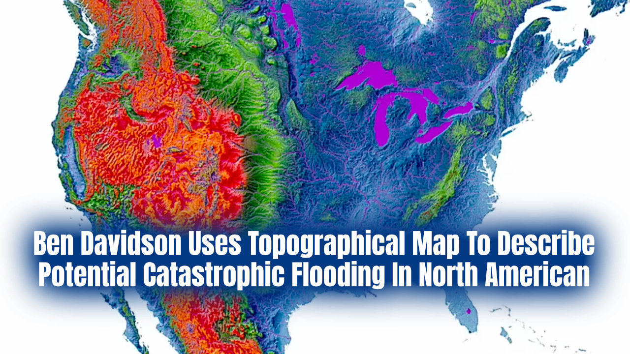
Ben Davidson Uses Topographical Map To Describe Potential Catastrophic Flooding In North American
North American topographical maps illustrate potential catastrophic flooding pathways. Ben Davidson uses models to simulate ocean surges, focusing on the Gulf, Atlantic, and Pacific impacts. Geological evidence supports this cyclical event theory.
Original YouTube video:
https://www.youtube.com/watch?v=wHG_YQupTOk
See also:
The Coming Geomagnetic Pole Shift
https://www.sunfellow.com/magnetic-pole-shift/
Ancient Civilizations & Earth Disaster Cycles
https://rumble.com/c/AncientCivilizationsEarthDisasterCycles
................
Ben Davidson, SpaceWeatherNews on X:
@SunWeatherMan
SpaceWeatherNews Website
https://spaceweathernews.com/
SpaceWeatherNews (S0) YouTube Channel
https://www.youtube.com/@SpaceWeatherNewsS0s
Suspicious Observers
https://www.Suspicious0bservers.org
Observer Ranch
https://observerranch.com/
The Observer Review
https://theobserver.kit.com/
Solar Killshot Action Network
https://solarkillshot.org/
-
 52:22
52:22
Ancient Civilizations & Earth Disaster Cycles
25 days agoIs Civilization OLDER Than We Think? (Graham Hancock & Michael Button)
2151 -
 49:24
49:24
Donald Trump Jr.
3 hours agoPeter Navarro Went to Prison So You Won't Have to | TRIGGERED Ep,286
16.2K26 -
 LIVE
LIVE
Nerdrotic
12 hours agoNerdrotic at Night 528
353 watching -
 1:16:12
Kim Iversen
3 hours agoTrump Might Actually Run For A THIRD Term?! | Turbo Cancers Are Rising—Media Pretends It’s Fine
50.1K36 -
 1:09:38
TheCrucible
2 hours agoThe Extravaganza! EP: 60 with Special Guest: Vince Offer (10/27/25)
54.2K4 -
 1:04:18
Candace Show Podcast
4 hours agoCharlie's Angels Or Demons? Disturbing Footage Emerges. | Candace Ep 252
58.7K209 -
 LIVE
LIVE
Quite Frankly
6 hours agoThe Forest King, NPC Nation, Calls & EXTRAS | Lubomir Arsov 10/27/25
336 watching -
 LIVE
LIVE
The Mike Schwartz Show
2 hours agoTHE MIKE SCHWARTZ SHOW Evening Edition 10-27-2025
131 watching -
 13:53
13:53
Tundra Tactical
3 hours agoGlock Apocalypse - Tundy Meme Review
2.66K1 -
 LIVE
LIVE
Jamie Kennedy
15 hours agoThe Macabre Mind of Bill Moseley: Horror, Philosophy & the Spirit of Darkness| Ep 228 HTBITY
86 watching