Gino Recchia NBC26 Storm Shield Weather Forecast
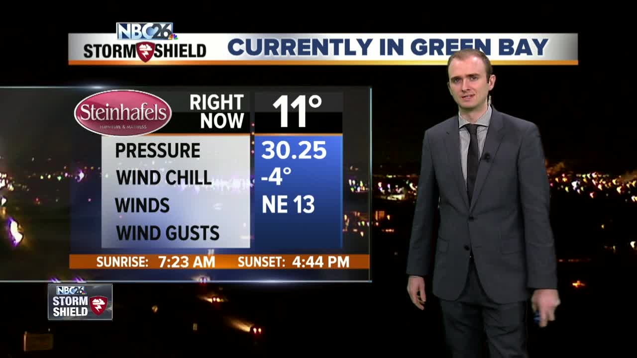
As expected, the snowstorm affected the southern portions of the viewing area. The cutoff line was generally the Highway 29 corridor. A half inch fell around the Green Bay area, further south into the Fox Cities 1 to 3 inches of snow fell. The highest totals were along Lake Michigan lakes to the lake effect influence. Snowfall totals got up to 6 inches around the Sheboygan area. One very impressive area was Two Rivers with a foot of snow! A lake effect snow band just sat right over the area during the overnight period. Interestingly enough, the Manitowoc area only got 3 to 5 inches. That is the nature of lake effect snow for you! Lake effect snow showers will linger into the evening hours but the band is beginning to drift southward. Any additional accumulation should remain minimal. It is possible that some light flurries or a light snow shower will persist on and off right along the shores of Lake Michigan tonight into tomorrow, but for everyone else, we will be done with the snowfall for now. It is going to get quite chilly tonight. Skies are going to remain mostly clear away from the lake and temperatures will fall into the single digits, very close to 0 degrees. There will be some areas tomorrow that will wake up below zero. With winds out of the north and northeast around 10 to 15 mph, those wind chilly will feel anywhere from -10 to -20 degrees in the morning. High temperatures will rise up near 10 degrees making it the coldest day of the winter so far. Winds will begin to subside in the late afternoon to about 5 mph out of the north and northeast. Monday will start off sunny but then clouds will begin to increase out of the west ahead of out next snow maker. Tuesday into Wednesday will be snowy days for Northeast Wisconsin. Right now it appears that a band of snow will quickly sweep through early Tuesday morning north of Highway 29, then a lull until lunch hour and then widespread snowfall overspreads the entire area and continues into the morning commute Wednesday. Snowfall totals at this time will range from 3 to 6 inches area-wide with some locally higher totally between 6 to 8 inches. A weak clipper on Thursday may bring a light dusting of snowfall following by some very chilly air on Friday with highs once again in the single digits.
-
 1:45
1:45
WGBA
1 year agoStudents excited to start at "huge and beautiful" Vel Phillips Middle School
310 -
 3:36
3:36
WGBA
3 years agoGino Recchia NBC26 Weather Forecast
10 -
 2:33
2:33
WGBA
3 years agoGino Recchia NBC26 Weather Forecast
15 -
 3:46
3:46
WGBA
3 years agoGino Recchia NBC26 Weather Forecast
13 -
 3:32
3:32
WGBA
3 years agoGino Recchia NBC26 Weather Forecast
17 -
 3:08
3:08
WGBA
3 years agoGino Recchia NBC26 Weather Forecast
17 -
 3:24
3:24
WGBA
3 years agoGino Recchia NBC26 Weather Forecast
18 -
 1:55
1:55
WGBA
3 years agoGino Recchia NBC26 Weather Forecast
9 -
 4:18
4:18
WGBA
3 years agoGino Recchia NBC26 Weather Forecast
11 -
 2:53
2:53
WGBA
3 years agoGino Recchia NBC26 Weather Forecast
13