
MIchael Fish's NBC26 Storm Shield weather forecast
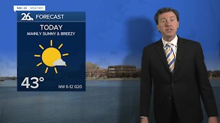
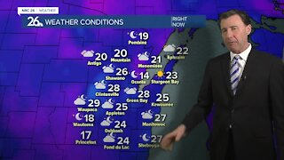
Today won't be too bad of a day with highs popping back up into the upper-20s to low-30s with a chance of a few flurries or even a few lake effect snow showers in Door and Kewaunee counties. Some minor accumulation will be possible there if any of these more persistent lake effect snow bands move onshore. It's the same story for tonight with areas closer to Lake Michigan possibly seeing a few lake effect snow showers swinging through as the winds slowly shift to the ENE. Again, some accumulation is possible in Kewaunee and Door or possibly Marinette as well. Lows will be around 20. A slow moving disturbance moves through Saturday also getting a little bit of a Lake Michigan influence. This could bring us some snow showers or flurries with highs in the low-30s. The brunt of a bigger system misses us to our south bringing snow to Illinois. Again, for Door, Kewaunee and Marinette counties, if any of these more persistent lake effect bands linger in one place, those counties could end up with a 2-day total of 1", 2 or even 3". This is not a guarantee at this time as lake effect bands are tough to predict. Saturday night looks quiet with lows in the upper-teens. Sunday looks fine with highs in the low-30s. Clouds will mix with sunshine. Much above normal temps return early next week. NO big snow is in the forecast the next 7-10 days. No big shots of arctic air are in the forecast for the next 7-days.
-
 1:45
1:45
WGBA
1 year agoStudents excited to start at "huge and beautiful" Vel Phillips Middle School
375 -
 2:33
2:33
WGBA
4 years agoMichael Fish's NBC 26 weather forecast
4 -
 2:19
2:19
WGBA
4 years agoMichael Fish's NBC 26 weather forecast
3 -
 2:26
2:26
WGBA
4 years agoMichael Fish's NBC 26 weather forecast
4 -
 2:24
2:24
WGBA
4 years agoMichael Fish's NBC 26 weather forecast
3 -
 2:27
2:27
WGBA
4 years agoMichael Fish's NBC 26 weather forecast
4 -
 1:57
1:57
WGBA
4 years agoMichael Fish's NBC 26 weather forecast
2 -
 2:31
2:31
WGBA
4 years agoMichael Fish's NBC 26 weather forecast
7 -
 1:50
1:50
WGBA
4 years agoMichael Fish's NBC 26 weather forecast
4 -
 2:27
2:27
WGBA
4 years agoMichael Fish's NBC 26 weather forecast
1