LIGHTNING STORMS + HEAT WAVE & COOL DOWN
Dangerous #Heat in the West; Coastal Flooding & High Rip Current Risk into the Weekend on the East Coast; Flash Flooding Possible in the Southeast #weather #meteorology #forecast
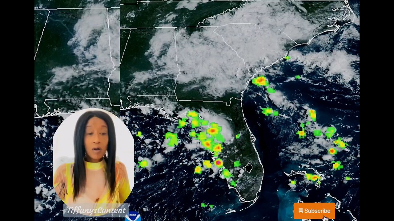
A dangerous, record heat wave continues for the Desert Southwest and the Central Valley of California through Saturday, and the Pacific Northwest through Tuesday. Coastal flooding is expected through tonight at high tide along the Eastern Seaboard from Erin, while the high rip current risk and dangerous surf continue through the weekend. Flash flooding possible today in Georgia and South Carolina. Read More >Active Systems:
The National Hurricane Center is issuing advisories on Hurricane
Erin, located over the northwestern Atlantic Ocean.
1. Near the Leeward Islands (AL90):
Showers and thunderstorms are showing some signs of organization in
association with a tropical wave located about a hundred miles
east-northeast of the northern Leeward Islands. Environmental #news
conditions appear conducive for further development of this system,
and a tropical depression or tropical storm is very likely to form
this weekend while it moves northwestward and then northward, in
between the northern Leeward Islands and Bermuda.
* Formation chance through 48 hours...high...80 percent.
* Formation chance through 7 days...high...90 percent. #tropicalstorm
2. Central Tropical Atlantic (AL99):
Showers and thunderstorms associated with a tropical wave located
about midway between Africa and the Windward Islands have become
less organized overnight. While there is still some chance that a
short-lived tropical depression could form during the next day or
so, the system is expected to move through a less conducive
environment into Saturday. The wave could reach a slightly more
favorable environment again late this weekend into early next week
as it moves westward at 10 to 15 mph over the central tropical
Atlantic and approaches the Lesser Antilles.
* Formation chance through 48 hours...medium...40 percent.
* Formation chance through 7 days...medium...50 percent.
3. Central Subtropical Atlantic:
A small area of low pressure located well southwest of the Azores
has weakened overnight, and no development is expected while it
drifts northward.
* Formation chance through 48 hours...low...near 0 percent.
* Formation chance through 7 days...low...near 0 percent.
Forecaster Blake nhc
other sources
nhc
tropical tidbits
star nesdis noaa gov
weather gov
spaghettimodels
-
 48:48
48:48
The Culture War with Tim Pool
1 hour agoThe West Is COLLAPSING Under Mass Migration | The Culture War's Across The Pond
9.8K27 -
 LIVE
LIVE
The Mel K Show
1 hour agoMORNINGS WITH MEL K - We Have Not Yet Begun to Fight - The Clock is Ticking! 11-28-25
829 watching -
 LIVE
LIVE
Film Threat
13 hours agoHOLLYWOOD FOR SALE! BLACK FRIDAY BLOW OUT! | Film Threat Livecast
109 watching -
 LIVE
LIVE
The Shannon Joy Show
2 hours agoSJ Show Nov 28 - The SJ Friday Matinee Watch Party With Commentary Featuring The Big Short!
41 watching -
 35:39
35:39
Grant Stinchfield
4 hours agoThe Medical Deep State Exposed — And McCullough Has the Receipts!
3.48K -
 LIVE
LIVE
Trumpet Daily
1 hour agoTrumpet Daily LIVE | Nov. 28, 2025
448 watching -
 LIVE
LIVE
LFA TV
15 hours agoLIVE & BREAKING NEWS! | FRIDAY 11/28/25
6,450 watching -
 2:00:18
Badlands Media
11 hours agoBadlands Daily – Nov. 28, 2025
90.1K13 -
 2:18:44
Nikko Ortiz
3 hours agoVR Ghost Of Tabor... | Rumble LIVE
12.2K2 -
 19:08
19:08
ThinkStory
4 hours agoSTRANGER THINGS SEASON 5 Volume 1 Ending Explained, Theories, & Details You Missed!
12.2K1