Weather or Not? Hurricane Erin is still on the move!
#HurricaneErin Moving Away from the #NorthCarolina Coast, Dangerous Surf & Rip Currents Continue; Hazardous Heat out West
Tropical storm conditions, storm surge flooding and coastal flooding continue today across the Outer Banks and portions of the Mid-Atlantic coast. Life-threatening rip currents and high surf continue to impact much of the East Coast through the end of the week. Hazardous, record heat will continue across the Western U.S. through the weekend. #Erin #hurricane #tropicalstorm
zoom earth nhc
Active Systems:
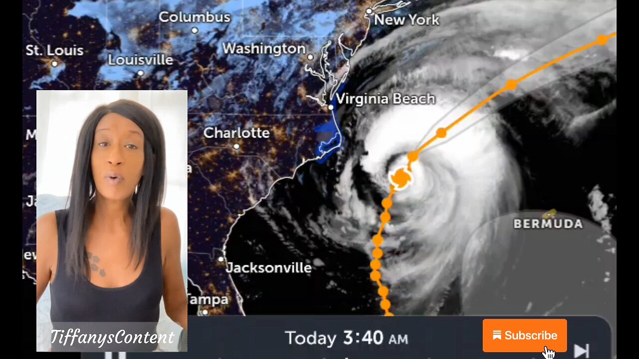
The National Hurricane Center is issuing advisories on Hurricane
Erin, located over the northwestern Atlantic Ocean.
1. Near the Leeward Islands in the Tropical Atlantic:
An area of showers and thunderstorms associated with a tropical
wave located a few hundred miles east of the Leeward Islands has
changed little over the past several hours. Environmental
conditions appear conducive for further development of this system,
and a tropical depression is likely to form this weekend while it
moves near or to the north of the northern Leeward Islands.
* Formation chance through 48 hours...medium..40 percent.
* Formation chance through 7 days...high...70 percent.
2. Eastern Tropical Atlantic (AL99):
Showers and thunderstorms associated with a tropical wave located
several hundred miles west-southwest of the Cabo Verde Islands show
some signs of organization. Environmental conditions appear
marginally favorable for additional development over the next day or
so while the system moves west-southwestward at around 15 mph, and
a short-lived tropical depression could form. In a couple of
days, environmental conditions are expected to become unfavorable
for further development.
* Formation chance through 48 hours...medium...40 percent.
* Formation chance through 7 days...medium...40 percent.
3. Central Atlantic:
A small area of low pressure located about 1200 miles southwest of
the Azores is producing limited showers and thunderstorms.
Upper-level winds are only marginally conducive for development
while the system moves slowly eastward over the next couple of days
* Formation chance through 48 hours...low...30 percent.
* Formation chance through 7 days...low...30 percent.
Forecaster Pasch
nhc
Erin will continue to produce life-threatening surf and rip currents along the beaches of the Bahamas, much of the east coast of the U.S., Bermuda, and Atlantic Canada during the next several days. Beachgoers in those areas should follow advice from lifeguards, local authorities, and beach warning flags. #forecast #flashflood #waves
Storm surge #flooding and tropical storm conditions will continue on the North Carolina Outer Banks today (21 August). The #storm surge will be accompanied by large waves, leading to significant beach erosion and overwash, making some roads impassible. #weather #meteorology
Tropical storm conditions are expected today along the #Virginia coast. Wind gusts to tropical storm force are likely along portions of the remainder of the U.S. Mid-Atlantic and southern New England coasts today through early Friday.
other sources
nhc
tropical tidbits
star nesdis noaa gov
weather gov
spaghettimodels
-
 LIVE
LIVE
LFA TV
9 hours agoBREAKING NEWS ALL DAY! | TUESDAY 9/23/25
14,320 watching -
 27:39
27:39
Tucker Carlson
1 hour agoThe 9/11 Files: The CIA’s Secret Mission Gone Wrong | Ep 1
12 -
 LIVE
LIVE
JULIE GREEN MINISTRIES
1 hour agoLIVE WITH JULIE
18,961 watching -
 LIVE
LIVE
The Chris Salcedo Show
11 hours agoMajor MAHA Moves
685 watching -
 LIVE
LIVE
Game On!
16 hours agoCollege Football SHOWDOWN! Week 5 EARLY Preview!
282 watching -
 9:26
9:26
Millionaire Mentor
16 hours agoMegyn Kelly STUNNED as Tucker Carlson Reveals The Truth About Charlie Kirk
48.5K21 -
 7:30
7:30
Blackstone Griddles
13 hours agoEasy Weeknight Meals: Meatloaf Sliders on the Blackstone Griddle
2.45K4 -
 8:47
8:47
DropItLikeItsScott
15 hours ago $0.89 earnedDid HI-POINT Just Create The Next Best AR? Hi-Point HP15 AR-15 Pistol
4K1 -
 39:19
39:19
The Heidi St. John Podcast
3 days agoFirst Fan Mail Friday: From the White House to Your Questions
11.7K5 -
 LIVE
LIVE
BEK TV
23 hours agoTrent Loos in the Morning - 9/23/2025
171 watching