Premium Only Content

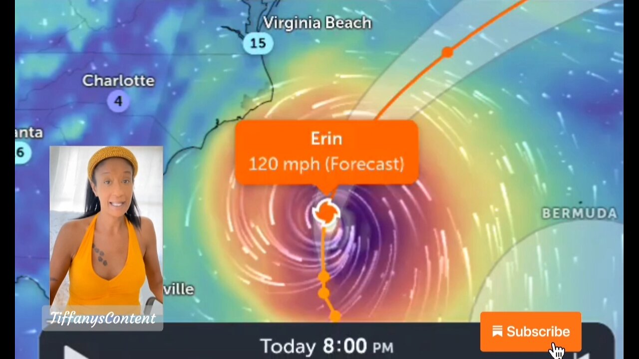
MAJOR HURRICANE ERIN 120+MPH GROWS TOWARDS THE U.S EAST COAST 🙏🏽
LARGE ERIN STRENGTHENS WHILE HEADED NORTH...
...BEACHGOERS ARE CAUTIONED AGAINST SWIMMING AT MOST U.S. EAST
COAST BEACHES DUE TO LIFE-THREATENING SURF AND RIP CURRENTS...
SUMMARY OF 1100 AM EDT...1500 UTC...INFORMATION
-----------------------------------------------
LOCATION...30.1N 73.7W
ABOUT 545 MI...880 KM WSW OF #BERMUDA
ABOUT 365 MI...590 KM SSE OF #CAPEHATTERAS NORTH CAROLINA
MAXIMUM SUSTAINED WINDS...110 MPH...175 KM/H
PRESENT MOVEMENT...N OR 360 DEGREES AT 13 MPH...20 KM/H
MINIMUM CENTRAL PRESSURE...941 MB...27.79 INCHES
#HURRICANE #majorhurricane #WEATHER #meteorology
WATCHES AND WARNINGS
-------------------
CHANGES WITH THIS ADVISORY:
A #TropicalStorm Warning has been issued from north of the #NorthCarolina / #Virginia border to Chincoteague, Virginia.
SUMMARY OF WATCHES AND WARNINGS IN EFFECT:
A Storm Surge Warning is in effect for...
* Cape Lookout to Duck, North Carolina
A Tropical Storm Warning is in effect for...
* Beaufort Inlet, North Carolina to Chincoteague, Virginia,
including Pamlico and Albemarle sounds.
A Tropical Storm Watch is in effect for...
* Bermuda
Erin is a large hurricane. Hurricane-force winds extend outward up
to 90 miles (150 km) from the center and tropical-storm-force winds
extend outward up to 265 miles (425 km).
The minimum central pressure estimated from Air Force Hurricane
Hunter observations is 941 mb (27.79 inches).
HAZARDS AFFECTING LAND
----------------------
Key messages for Erin can be found in the Tropical Cyclone
Discussion under AWIPS header MIATCDAT5 and WMO header WTNT45 KNHC.
WIND: Tropical storm conditions are expected over portions of the
North Carolina Outer Banks and the Virginia coastline beginning
late today. Elsewhere along the mid-Atlantic and southern New
England coast, wind gusts to tropical storm force are likely
Thursday through early Friday. Tropical storm conditions are
possible on Bermuda Thursday and Friday.
SURF: Swells generated by Erin will affect the Bahamas, Bermuda,
the east coast of the United States, and Atlantic Canada during the
next several days. These rough ocean conditions are expected to
cause life-threatening surf and rip currents. Please consult
products from your local weather forecast office for more
information.
nhc
Erin is expected to produce life-threatening surf and rip currents along the beaches of the Bahamas, much of the east coast of the U.S., Bermuda, and Atlantic Canada during the next several days. Beachgoers in those areas should follow advice from lifeguards, local authorities, and beach warning flags.
Storm surge flooding and tropical storm conditions are expected in the North Carolina Outer Banks beginning later today (20 August). The storm surge will be accompanied by large waves, leading to significant beach erosion and overwash, making some roads impassible.
Tropical storm conditions are expected on Thursday along the Virginia coast. Wind gusts to tropical storm force are likely along portions of the remainder of the U.S. Mid-Atlantic and southern New England coasts Thursday through early Friday.
Tropical storm conditions are possible on Bermuda on Thursday and Friday.
Observations from an Air Force Hurricane Hunter aircraft indicate that the hurricane has strengthened with peak 700 mb flight-level winds of 130 mph (115 knots) well to the east of the center. Using a reduction factor somewhat greater than that which would be used for eyewall winds, the intensity is set at 110 mph (95 knots) for this advisory. A dropsonde in the eye measured a surface pressure of 943 mb with 19 knot winds so the minimum central pressure has fallen to an estimated 941 mb. The hurricane has become better organized on satellite images this morning (20 August) with a symmetric-looking cloud pattern and numerous banding features. The eye has again become evident on the imagery and upper-level outflow is well-defined over all quadrants.
zoom earth
other sources
tropical tidbits
pivotal weather
weather gov
goes star
-
 29:37
29:37
Midwest Crime
1 day ago5 Cops Shot as Minnesota Raid Turns into Chaos
284 -
 11:08
11:08
It’s the Final Round
11 hours ago💰NFL Week 6 Best Bets🔥Player Prop Picks, Parlays, Predictions FREE Today October 12th
306 -
 29:03
29:03
itsSeanDaniel
2 days agoIllegal Migrants REVEAL How They're INVADING Europe 🇪🇺
2.09K6 -
 8:08
8:08
MattMorseTV
16 hours ago $9.83 earnedThe USA - China TRADE WAR just went NUCLEAR.
16.8K29 -
 20:22
20:22
Real Estate
8 days ago $3.72 earnedNumber 1 Indicator Home Prices ARE ABOUT TO CRASH
4.64K2 -
 30:09
30:09
Afshin Rattansi's Going Underground
18 hours ago‘Gaza Will Haunt Israel for Generations’- Mika Almog Granddaughter of Former President Shimon Peres
10.7K6 -
 15:36
15:36
Nikko Ortiz
13 hours agoBring Back Public Shaming...
9.09K7 -
 2:43:41
Side Scrollers Podcast
19 hours agoAsmongold Says The Online Left Are “ANIMALS” + Hasan Collar-Gate Gets WORSE + More | Side Scrollers
20.9K15 -
 1:33:41
Dinesh D'Souza
2 days agoThe Dragon's Prophecy Film
85.3K58 -
 LIVE
LIVE
Lofi Girl
2 years agoSynthwave Radio 🌌 - beats to chill/game to
335 watching