HURRICANE ERIN GROWS IN SIZE! MASSIVE STATE OF EMERGENCY +MANDATORY EVACUATIONS
HURRICANE HUNTER AIRCRAFT INVESTIGATING #ERIN ... #Hurricane #hurricaneerin
...LIFE-THREATENING RIP CURRENTS EXPECTED ALONG U.S. EAST COAST
BEACHES...
SUMMARY OF 800 PM EDT...0000 UTC...INFORMATION
----------------------------------------------
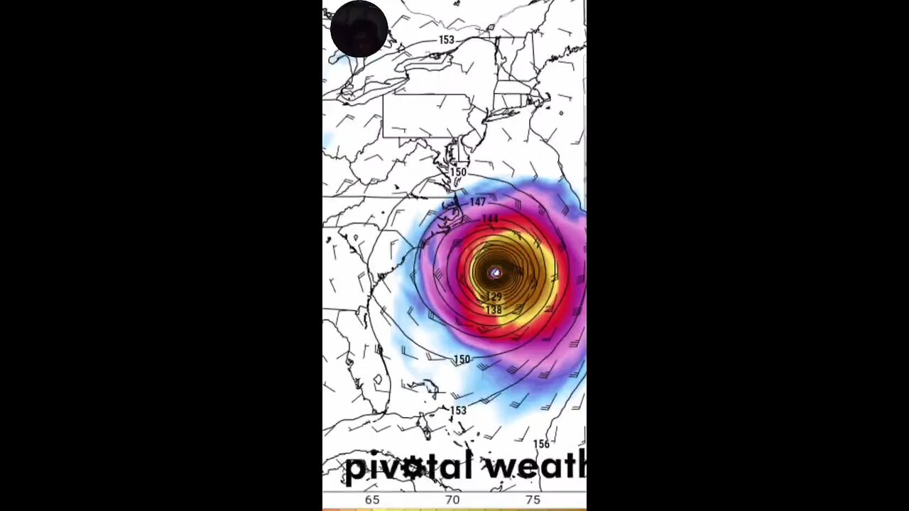
LOCATION...27.3N 72.7W
ABOUT 585 MI...940 KM SW OF BERMUDA
ABOUT 570 MI...915 KM SSE OF CAPE HATTERAS NORTH CAROLINA
MAXIMUM SUSTAINED WINDS...105 MPH...165 KM/H
PRESENT MOVEMENT...NNW OR 330 DEGREES AT 10 MPH...17 KM/H
MINIMUM CENTRAL PRESSURE...959 MB...28.32 INCHES
SUMMARY OF WATCHES AND WARNINGS IN EFFECT:
A Storm Surge Warning is in effect for...
* Cape Lookout to Duck, #NorthCarolina
A Tropical Storm Warning is in effect for...
* Beaufort Inlet, North Carolina to Duck, North Carolina including
Pamlico and Albemarle sounds.
A Tropical Storm Watch is in effect for...
* North of Duck, North Carolina to Chincoteague, #Virginia
* Bermuda
Erin is expected to produce life-threatening surf and rip currents along the beaches of the Bahamas, much of the east coast of the U.S., Bermuda, and Atlantic Canada during the next several days. Beachgoers in those areas should follow advice from lifeguards, local authorities, and #beach warning flags.
Storm surge flooding and tropical storm conditions are expected in the North Carolina Outer Banks beginning late Wednesday or #Wednesday night, where Tropical Storm and #Storm Surge Warnings are in effect. The storm surge will be accompanied by large waves, leading to significant beach erosion and overwash, making some roads impassible.
Since the shear over Erin appears to have lessened, and the system will continue to traverse warm waters for the next couple of days, some re-strengthening could occur. The future intensity is dependent on whether the inner-core eyewall structure becomes re-established. The official forecast conservatively shows a slight increase in intensity similar to the model consensus but the LGEM guidance shows a little more strengthening than that. Later in the forecast period, Erin should gradually weaken over the cooler waters of the north Atlantic and lose its tropical characteristics in 4–5 days.
#WIND : #Tropicalstorm conditions are expected over portions
of the North Carolina Outer Banks beginning late Wednesday or
Wednesday night. Tropical storm conditions are possible in the
watch area north of Duck, North Carolina to Cape Charles Light
beginning Thursday. Tropical storm conditions are possible in
Bermuda beginning Thursday.
SURF: Swells generated by Erin will affect the Bahamas, Bermuda,
the east coast of the United States, and Atlantic Canada during the
next several days. These rough ocean conditions are expected to
cause life-threatening surf and rip currents. Please consult
products from your local weather forecast office for more
information
#atlantic #AtlanticOcean
-
 LIVE
LIVE
Kim Iversen
2 hours agoNetanyahu Vs Trump: Trump Says the War Is Over — Netanyahu Says Otherwise...
1,215 watching -
 LIVE
LIVE
Dr Disrespect
8 hours ago🔴LIVE - DR DISRESPECT - BATTLEFIELD 6 - JET CRASHES, EXPLOSIONS, 360 NO-SCOPES
2,428 watching -
 1:18:10
vivafrei
4 hours agoTom Homan "Bribery" Scandal Smells Like Russia-Gate 3.0! Ostrich Farm Update! Tommy Robinson & MORE!
97.3K61 -
 1:43:33
The Quartering
4 hours agoLiberal MELTDOWN As Trump Does The Impossible, Charlie Kirk Day, TPUSA Halftime Show & More
95.2K64 -
 LIVE
LIVE
StoneMountain64
4 hours agoBattlefield 6 Flick Keybind is WILD
140 watching -
 LIVE
LIVE
LFA TV
21 hours agoLIVE & BREAKING NEWS! | MONDAY 10/13/25
883 watching -
 LIVE
LIVE
freecastle
7 hours agoTAKE UP YOUR CROSS- Let the peace of Christ rule your hearts!
91 watching -
 1:02:56
The HotSeat
5 hours agoTrump "The Peacemaker", Unless You're Antifa!!! Part II
20.6K2 -
 2:01:26
Film Threat
1 day agoVERSUS: TRON: ARES VS. TRON LEGACY VS. TRON! BATTLE ON THE GRID! | Film Threat Versus
12.5K -
![[Ep 768] Trump: The President of Peace | Schumer Looking Worse by the Day | Columbus Day](https://1a-1791.com/video/fwe2/d0/s8/1/g/Q/s/q/gQsqz.0kob-small-Ep-768-Trump-The-President-.jpg) 2:19:32
2:19:32
The Nunn Report - w/ Dan Nunn
3 hours ago[Ep 768] Trump: The President of Peace | Schumer Looking Worse by the Day | Columbus Day
16.6K8