Premium Only Content

BAHAMA MAMA
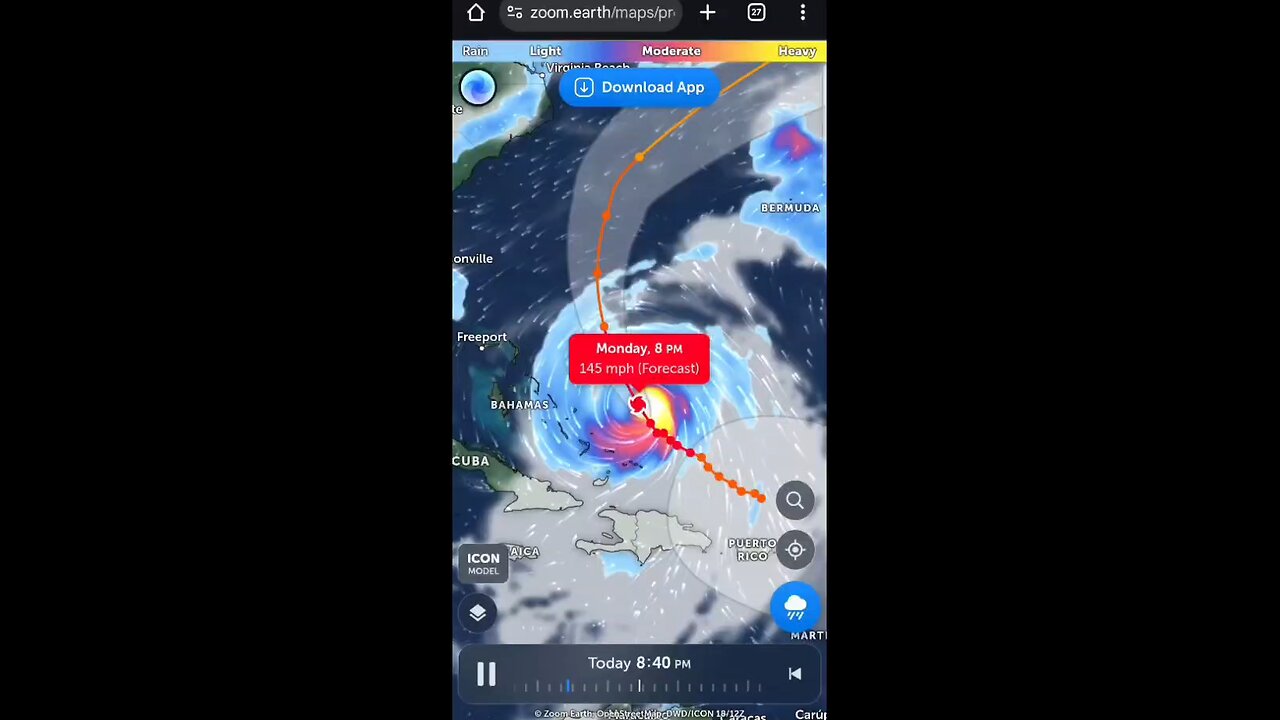
MAJOR HURRICANE ERIN LIKELY TO BECOME EVEN LARGER OVER THE COMING DAYS...
SUMMARY OF 200 PM EDT...1800 UTC...INFORMATION
----------------------------------------------
LOCATION...23.5N 71.1W
ABOUT 140 MI...220 KM N OF GRAND TURK ISLAND
ABOUT 850 MI...1370 KM SSE OF CAPE HATTERAS NORTH CAROLINA
MAXIMUM SUSTAINED WINDS...140 MPH...220 KM/H
PRESENT MOVEMENT...WNW OR 300 DEGREES AT 10 MPH...17 KM/H
MINIMUM CENTRAL PRESSURE...937 MB...27.67 INCHES
WATCHES AND WARNINGS
--------------------
CHANGES WITH THIS ADVISORY:
None.
SUMMARY OF WATCHES AND WARNINGS IN EFFECT:
A Tropical Storm Warning is in effect for...
* Turks and Caicos Islands
* Southeast Bahamas
A Tropical Storm Watch is in effect for...
* Central Bahamas
A Tropical Storm Warning means that tropical storm conditions are
expected somewhere within the warning area.
A Tropical Storm Watch means that tropical storm conditions are
possible within the watch area, in this case within 12 to 24 hours.
Interests in the northwestern Bahamas, the North Carolina Outer
Banks, and Bermuda should monitor the progress of Erin.
For storm information specific to your area, please monitor
products issued by your national meteorological service.
DISCUSSION AND OUTLOOK
----------------------
At 200 PM EDT (1800 UTC), the center of Hurricane Erin was located
near latitude 23.5 North, longitude 71.1 West. Erin is moving toward
the west-northwest near 10 mph (17 km/h). A turn to the northwest
is expected later today, followed by a turn to the north on
Tuesday. On the forecast track, the core of Erin is expected to
pass to the east of the southeastern Bahamas today and move between
Bermuda and the east coast of the United States by the middle of
the week.
Maximum sustained winds are near 140 mph (220 km/h) with higher
gusts. Erin is a category 4 hurricane on the Saffir-Simpson
Hurricane Wind Scale. Some additional strengthening is possible
today. Erin is likely to remain a dangerous major hurricane
through the middle of this week.
Hurricane-force winds extend outward up to 80 miles (130 km) from
the center and tropical-storm-force winds extend outward up to 230
miles (370 km).
The estimated minimum central pressure is 937 mb (27.67 inches).
HAZARDS AFFECTING LAND
----------------------
Key messages for Erin can be found in the Tropical Cyclone
Discussion under AWIPS header MIATCDAT5 and WMO header WTNT45 KNHC.
RAINFALL: Outer bands of Erin will produce localized areas of heavy
rainfall across portions of Hispaniola through today and through
Tuesday for the Turks and Caicos and the Bahamas east from San
Salvador Island. Additional rainfall of 2 to 4 inches, with
locally higher amounts to 6 inches, are forecast.
-
 2:57:12
TimcastIRL
5 hours agoDems SHUTDOWN Government For NO KINGS Insurrection, Block Police Pay | Timcast IRL
223K62 -
 1:47:20
Badlands Media
11 hours agoBaseless Conspiracies Ep. 154
27.9K22 -
 2:04:08
Inverted World Live
5 hours agoRex Jones Calls In From The Gray Area | Ep. 122
23.7K3 -
 5:56:17
Rallied
7 hours ago $2.30 earnedBF6 with THE BOYS
31.4K4 -
 1:05:18
Flyover Conservatives
23 hours agoThe SEAL-Turned-CEO Paying Off Millions in Veteran Medical Debt: JOIN THE MISSION! - Bear Handlon, Born Primitive | FOC Show
35.9K3 -
 LIVE
LIVE
Drew Hernandez
9 hours agoTRUMP'S GAZA PEACE PLAN PHASE 1 & TRUMP THREATENS PUTIN WITH TOMAHAWKS
747 watching -
 1:18:38
Glenn Greenwald
7 hours agoProf. John Mearsheimer on Trump's Knesset Speech, the Israel/Hamas Ceasefire, Russia and Ukraine, and More | SYSTEM UPDATE #530
107K66 -
 2:21:37
Tucker Carlson
6 hours agoAlex Jones Warns of the Globalist Death Cult Fueling the Next Civil War and Rise of the Antichrist
81.4K369 -
 12:35
12:35
Clownfish TV
14 hours agoJimmy Kimmel Return NOT Helping Disney AT ALL! DIS Stock Keeps Falling! | Clownfish TV
31.3K6 -
 LIVE
LIVE
Eternal_Spartan
7 hours ago🟢 Eternal Spartan Plays Final Fantasy 7 Rebirth Ep. 10 | USMC Vet
438 watching