MAJOR HURRICANE ERIN EXPECTED TO INTENSIFY AGAIN WHILE GROWING IN SIZE...
EXPECTED TO INTENSIFY AGAIN WHILE GROWING IN SIZE...
#Hurricane #majorhurricane #storm #turksandcaicos #Bahamas #Puertorico #weather #flood
SUMMARY OF 500 PM AST...2100 UTC...INFORMATION
----------------------------------------------
LOCATION...21.7N 68.5W
ABOUT 275 MI...445 KM NW OF SAN JUAN PUERTO RICO
ABOUT 165 MI...270 KM E OF GRAND TURK ISLAND
MAXIMUM SUSTAINED WINDS...125 MPH...205 KM/H
PRESENT MOVEMENT...WNW OR 295 DEGREES AT 13 MPH...20 KM/H
MINIMUM CENTRAL PRESSURE...946 MB...27.94 INCHES
WATCHES AND WARNINGS
--------------------
CHANGES WITH THIS ADVISORY:
None.
SUMMARY OF WATCHES AND WARNINGS IN EFFECT:
A Tropical Storm Warning is in effect for...
* Turks and Caicos Islands
* Southeast Bahamas
A Tropical Storm Warning means that tropical storm conditions are
expected somewhere within the warning area, in this case within 24
hours.
Interests elsewhere in the central Bahamas, the North Carolina
Outer Banks, and Bermuda should monitor the progress of Erin.
For storm information specific to your area, please monitor
products issued by your national meteorological service.
nhc
Bands of heavy rainfall will continue across portions of Puerto Rico and the Virgin Islands through tonight, but are expected to diminish by Monday. Locally considerable flash and urban flooding, along with landslides or mudslides, are possible.
Tropical storm conditions are expected in the Turks and Caicos Islands and in the southeast Bahamas tonight and Monday.
Erin is expected to produce life-threatening surf and rip currents along the beaches of the Bahamas, much of the east coast of the U.S., Bermuda, and Atlantic Canada during the next several days.
Interests along the Outer Banks of North Carolina and Bermuda should monitor the progress of Erin as there is a risk of strong winds associated with the outer rainbands during the middle part of the week.
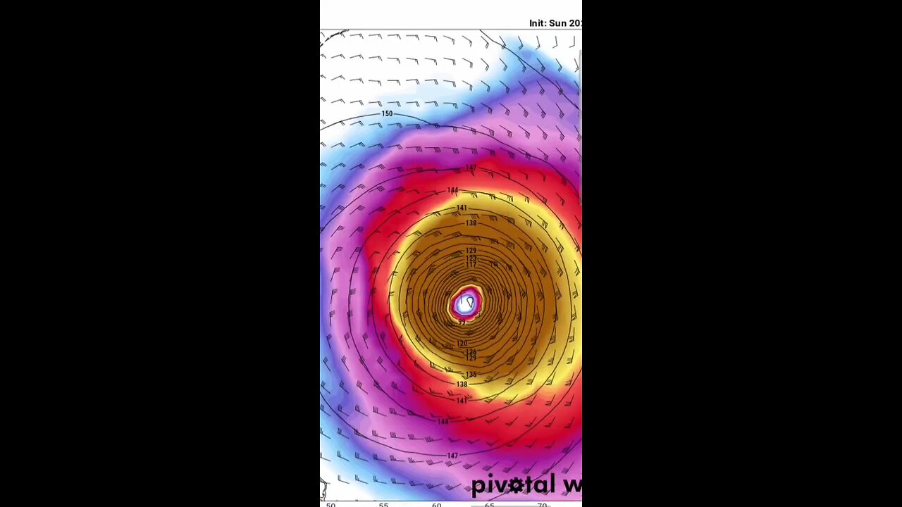
Erin continues to have a well-organized cloud pattern with numerous convective banding features and strong upper-level outflow. Satellite data indicate numerous lightning flashes in these cloud bands. The intensity estimate is held at 125 mph (110 knots) for this advisory, which is somewhat below the Dvorak values, but close to the estimate based on the most recent aerial reconnaissance mission. Another Air Force Hurricane Hunter plane is scheduled to investigate Erin in a few hours to provide an update on the strength of the hurricane.
zoom earth
other sources
tropical tidbits
pivotal weather
goes star
-
 3:26:25
Joe Donuts Live
4 hours ago🟢 Lost in Space with My Clones: The Alters Adventure Begins
21.6K -
 7:20:22
Dr Disrespect
13 hours ago🔴LIVE - DR DISRESPECT - TRIPLE THREAT CHALLENGE - WINNING AT EVERYTHING
203K12 -
 2:35:33
Chrono
6 hours agoBirthday-eve Stream | Helldivers II
18.4K1 -
 54:40
54:40
BonginoReport
1 day agoLABOR DAY SPECIAL! The Best of Nightly Scroll - Nightly Scroll w/ Hayley Caronia (Ep.124)
119K14 -
 2:39:21
Joker Effect
4 hours agoReviewing the downfall of Kick Streaming. Kick streamers welcome to Rumble! Stake bombshell found!
27.9K1 -
 1:06:10
Russell Brand
13 hours agoThe Greatest Lie Ever Told? - SF625
92K111 -
 3:25:13
elwolfpr
5 hours agoBlack Ops 6: Rise of the Relentless
10.5K1 -
 LIVE
LIVE
Phyxicx
4 hours agoChillin - For The King - 9/1/2025
14 watching -
 LIVE
LIVE
Spartan
10 hours agoNew Game+ on E33, then back to Halo Grind
60 watching -
 7:12:18
GrimmHollywood
10 hours ago🔴LIVE • GRIMM HOLLYWOOD • SKATE EARLY ACCESS • BRRRAP PACK • READY OR NOT •
20.1K4