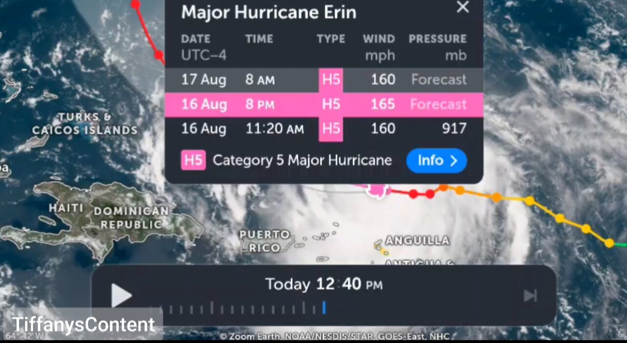
CATASTROPHIC CATEGORY 5 HURRICANE...
AIR FORCE RESERVE HURRICANE HUNTERS FIND ERIN IS NOW A
CATASTROPHIC CATEGORY 5 HURRICANE...
Reports from an Air Force Reserve Hurricane Hunter aircraft
indicate that Erin has become a Category 5 hurricane on the
Saffir-Simpson Hurricane Wind Scale with maximum sustained winds
near 160 mph (255 km/h). The minimum pressure has fallen to near
917 mb (27.08 inches). The next intermediate advisory will be issued
at 200 PM AST (1800 UTC).
SUMMARY OF 1120 AM AST...1520 UTC...INFORMATION
----------------------------------------------
LOCATION...19.7N 62.8W
ABOUT 105 MI...170 KM N OF ANGUILLA
MAXIMUM SUSTAINED WINDS...160 MPH...255 KM/H
PRESENT MOVEMENT...W OR 280 DEGREES AT 17 MPH...28 KM/H
MINIMUM CENTRAL PRESSURE...917 MB...27.08 INCHES
$$
Forecaster Beven/Kelly
Heavy rainfall at times through Sunday across the northern Leeward Islands, the Virgin Islands, and Puerto Rico may lead to locally considerable flash and urban flooding, along with landslides or mudslides.
Gusts to tropical storm force in Erin's outer rainbands are likely in portions of the northern Leeward Islands through tonight and over portions of the Virgin Islands and Puerto Rico later today (16 August) through Sunday. Tropical-storm force wind gusts are possible in the Turks and Caicos Islands and Southeast Bahamas
Erin is expected to produce life-threatening surf and rip currents along the beaches of the Bahamas, much of the east coast of the U.S., and Atlantic Canada next week.
Interests in Bermuda should continue to monitor the progress of Erin since there is a risk of strong winds, heavy rainfall, and high surf by the middle part of next week.
Erin has continued to rapidly strengthen during the past 6 hours and is now a category 4 hurricane. Reports from Air Force Reserve Hurricane Hunter aircraft indicate that the central pressure has fallen to 925 mb inside a 6 nautical miles wide eye, and flight-level winds in the northern eyewall support surface winds in the 130–135 knots range. The initial intensity is increased to 155 mph (135 knots), a 70-knots increase since 24 hours ago. The aircraft, along with land-based radar data from Sint Maarten, report that an outer eyewall is starting to form. However, this has yet become apparent in the aircraft wind data.
The hurricane has been moving a bit to the left of the previous forecast track with the initial motion of 280/15. The track guidance suggests that Erin will turn back to the west-northwest with a decrease in forward speed during the next 6–12 hours on the south side of a subtropical ridge.
-
 LIVE
LIVE
Badlands Media
9 hours agoBaseless Conspiracies Ep. 154
4,351 watching -
 LIVE
LIVE
Inverted World Live
4 hours agoRex Jones Calls In From The Gray Area | Ep. 122
1,803 watching -

Rallied
6 hours ago $1.27 earnedBF6 with THE BOYS
26.3K4 -
 1:05:18
Flyover Conservatives
22 hours agoThe SEAL-Turned-CEO Paying Off Millions in Veteran Medical Debt: JOIN THE MISSION! - Bear Handlon, Born Primitive | FOC Show
25K2 -
 LIVE
LIVE
Drew Hernandez
8 hours agoTRUMP'S GAZA PEACE PLAN PHASE 1 & TRUMP THREATENS PUTIN WITH TOMAHAWKS
658 watching -
 1:18:38
Glenn Greenwald
6 hours agoProf. John Mearsheimer on Trump's Knesset Speech, the Israel/Hamas Ceasefire, Russia and Ukraine, and More | SYSTEM UPDATE #530
98.3K57 -
 2:21:37
Tucker Carlson
4 hours agoAlex Jones Warns of the Globalist Death Cult Fueling the Next Civil War and Rise of the Antichrist
70.4K305 -
 12:35
12:35
Clownfish TV
12 hours agoJimmy Kimmel Return NOT Helping Disney AT ALL! DIS Stock Keeps Falling! | Clownfish TV
20K5 -
 LIVE
LIVE
Eternal_Spartan
6 hours ago🟢 Eternal Spartan Plays Final Fantasy 7 Rebirth Ep. 10 | USMC Vet
174 watching -
 2:10:42
RiftTV
7 hours agoTrump SECURES Hostages, ACCIDENTALLY Admits Foreign Gov CONTROLS Him? | The Rift | Gerald Morgan Jr.
47.6K27