African Union Urges Use of World Map Showing Africa's True Size | Firstpost Africa | N18G
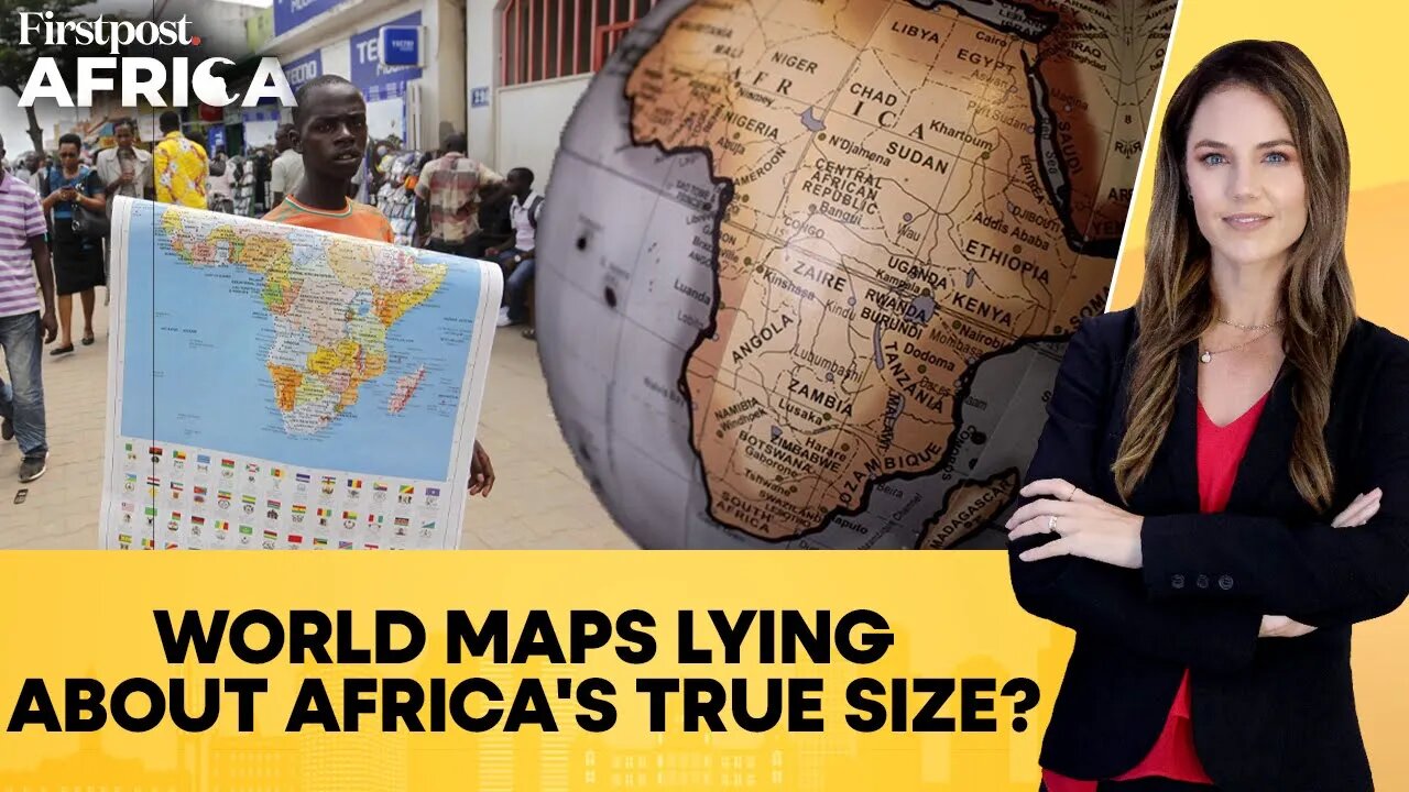
Many world maps use the Mercator projection, created in 1569 by Flemish cartographer Gerardus Mercator for navigation. While useful for sailors, it distorts the size of landmasses, enlarging regions near the poles like Europe, North America, and Greenland, while shrinking Africa and South America. On a Mercator map, Greenland appears nearly the same size as Africa, when in reality Africa is about 14 times larger. This distortion has sparked calls, especially from African leaders and educators, for a more accurate representation. Alternatives like the Equal Earth projection aim to show continents in their true proportions, challenging centuries of map bias.
---
Mercator Projection | Geradus Mercator | Europe | North America | Greenland | South America | Map Distortion | Map Representation | Equal Earth Projection | Map Bias | Firstpost Africa | Alyson Le Grange | Africa | Global South | Geopolitics | Military Coup | Environment | Climate Change | Firstpost | News Live | World News | Latest News | Global News | International News | News | Trending News
#mercator #geradusmercator #mapdistortion #africanunion #mapping #maprepresentation #firstpostafrica #africa #alysonlegrange #globalsouth #militarycoup #firstpost #newslive #worldnews #latestnews #globalnews #news #internationalnews #trendingnews
Firstpost is an Indian news and media website. Get all the incisive opinions, in-depth analyses and other visual stories that matter to you and the world right here on this channel.
Subscribe to Firstpost channel and press the bell icon to get notified when we go live.
https://www.youtube.com/@Firstpost
Follow Firstpost on Instagram:
https://www.instagram.com/firstpost/
Follow Firstpost on Facebook:
https://www.facebook.com/firstpostin/
Follow Firstpost on Twitter:
https://twitter.com/firstpost
Follow Firstpost on WhatsApp:
https://www.whatsapp.com/channel/0029Va6zOIrEQIamseyg762V
-
 4:57
4:57
Firstpost
4 hours agoZelensky Dials PM Modi Ahead of Putin Meet | Vantage with Palki Sharma | N18G
2 -
 18:52
18:52
Colion Noir
7 hours agoCourt Rules You Don't Need AR-15s For Self Defense, Mayor's Message If You Love Kids Ban AR-15s
10.7K38 -
 DVR
DVR
Nerdrotic
3 hours ago $1.92 earnedThe Mysteries of Mars and the Moon with Mike Bara | Forbidden Frontier #114
10.6K3 -
 LIVE
LIVE
The Mel K Show
2 hours agoMel K & Chas Holloway | An Opposing Theory: The AI & Tyranny Question | 8-31-25
515 watching -
 LIVE
LIVE
Rallied
2 hours ago $1.26 earnedSolo Challenges All Day
148 watching -
 LIVE
LIVE
IsaiahLCarter
2 days agoGrandmasters and Heretics || APOSTATE RADIO #027
75 watching -
 3:03:40
Barry Cunningham
6 hours agoPRESIDENT TRUMP IS THE TROLLER-IN-CHIEF AND MORE BREAKING NEWS!
33.5K26 -
 13:07
13:07
Robbi On The Record
4 hours ago $1.90 earnedSweet Poison: The Big Fat Lie That’s Killing America
14.4K7 -
 1:00:09
Sarah Westall
3 hours agoFlorida Surgeon General: Operation Warp Speed plus Attacks on RFK Jr w/ Dr Ladapo
18.1K10 -
 11:52
11:52
Tundra Tactical
8 hours ago $1.18 earnedWhy the SIG P320 Is the King of Gun Memes 💥😂
13.3K