MAJOR HURRICANE ERIN INTENSIFIES takes path CARIBBEAN VIRGIN P.RICO LEEWARD DOMINICAN TURKS BAHAMAS
MAJOR HURRICANE ERIN INTENSIFIES takes path #CARIBBEAN #VIRGINISLANDS #PUERTORICO #LEEWARDISLANDS #DOMINICANREPUBLIC #TURKSANDCAICOSISLANDS #BAHAMAS
#ERIN STILL MOVING QUICKLY WESTWARD...
... #FORECAST TO BECOME A #HURRICANE OVER THE CENTRAL #TROPICALSTORMERIN
ATLANTIC IN A COUPLE OF DAYS...
#TROPICALSTORM #MAJORHURRICANE
SUMMARY OF 500 PM AST...2100 UTC...INFORMATION
----------------------------------------------
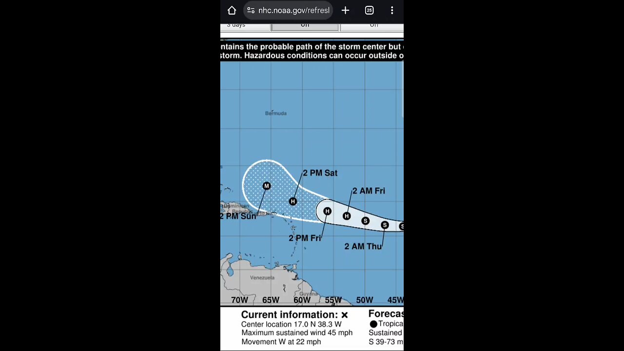
LOCATION...17.0N 38.3W
ABOUT 950 MI...1525 KM W OF THE CABO VERDE ISLANDS
ABOUT 1635 MI...2630 KM E OF THE NORTHERN LEEWARD ISLANDS
MAXIMUM SUSTAINED WINDS...45 MPH...75 KM/H
PRESENT MOVEMENT...W OR 265 DEGREES AT 22 MPH...35 KM/H
MINIMUM CENTRAL PRESSURE...1006 MB...29.71 INCHES
WATCHES AND WARNINGS
--------------------
There are no coastal watches or warnings in effect.
Interests in the northern Leeward Islands, Virgin Islands, and
Puerto Rico should monitor the progress of Erin.
DISCUSSION AND OUTLOOK
North Atlantic...Caribbean Sea and the Gulf of America:
Active Systems:
The National Hurricane Center is issuing advisories on Tropical
Storm Erin, located over the central tropical Atlantic.
1. Southwestern Gulf:
A tropical wave over the northwestern Caribbean Sea is producing
disorganized showers and thunderstorms extending across eastern
Honduras, northeastern Nicaragua and adjacent marine areas. This
system is forecast to move west-northwestward and cross the Yucatan
Peninsula on Wednesday with no significant increase in
organization. Some development of this system is possible after it
emerges across the southwestern Gulf beginning on Thursday while
the system moves to the west-northwest or northwest at 10 to 15 mph.
* Formation chance through 48 hours...low...10 percent.
* Formation chance through 7 days...low...20 percent.
2. Northwestern Atlantic:
A non-tropical area of low pressure located a few hundred miles
southeast of Nova Scotia, Canada, is producing disorganized shower
and thunderstorm activity to the west of its center. Some limited
tropical or subtropical development is possible through early
Wednesday as the low meanders near the relatively warm waters of the
Gulf Stream. The system is expected to move northward over cooler
waters later on Wednesday, ending its chances for tropical
development.
* Formation chance through 48 hours...low...10 percent.
* Formation chance through 7 days...low...10 percent.
-
 28:53
28:53
Afshin Rattansi's Going Underground
3 days agoTrump Has Surrounded Himself With Neocons AGAIN, War After War is Coming! (James Carden)
1.76K7 -
 1:54:50
Badlands Media
7 hours agoDevolution Power Hour Ep. 398: Economic Warfare, Trump’s Strategy, and the Coming Reckoning
46.2K22 -
 2:08:19
Inverted World Live
5 hours agoInvasion of the Lectern Guy | Ep. 124
32.7K4 -
 2:54:29
TimcastIRL
5 hours agoDemocrats Declare STATE OF EMERGENCY Over ICE Raids, DHS ATTACKED, CIVIL WAR | Timcast IRL
221K126 -
 2:37:25
TheSaltyCracker
5 hours agoAlex Jones Gets Screwed ReeEEStream 10-15-25
84.6K206 -
 58:25
58:25
Man in America
9 hours agoPaper Silver IMPLODES: Experts Predict HUNDREDS PER OUNCE is Coming
28.4K16 -
 LIVE
LIVE
Drew Hernandez
12 hours agoSENIOR ISRAELI OFFICIALS CLAIM GAZA WAR NOT OVER & ILLEGAL ALIENS COORDINATE ANOTHER ATTACK ON ICE?
808 watching -
 LIVE
LIVE
SpartakusLIVE
5 hours agoLIVE from VACATION || #1 Greek God of a Streamer
413 watching -
 LIVE
LIVE
Alex Zedra
4 hours agoLIVE! New Devour Map
401 watching -
 2:20:45
Geeks + Gamers
5 hours agoGeeks+Gamers Play- FALL GUYS
26.1K