Michael Fish's NBC26 New Year's Eve weather forecast
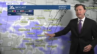
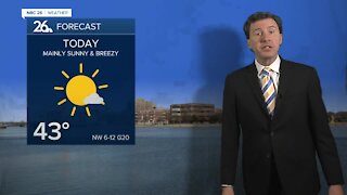
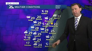
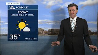
Things will be going downhill as we head through the afternoon into the night with a batch of snow on the way. Skies will be mostly cloudy as temperatures rise into the lower- to mid-30s by noon. Initially, a wintry mix will begin for areas along and south from Oshkosh to Manitowoc. Some of that mix will persist for those areas from noon until 3 or 4 pm. The farther south you live towards Sheboygan, the longer the wintry mix will last towards that 3 to 4 pm time. Further north, precipitation will begin and last throughout the entire event in the form of snowfall. The peak of the snow will be during the afternoon into the evening. Snow will turn lighter after 10pm and linger into flurries or a few light snow showers by midnight. A couple light snow showers and flurries will last into early Tuesday morning before high pressure moves in. Total snowfall accumulation will be 3-5" for almost everyone with a few isolated 6" totals possible. The exception will be our northern and northwestern counties of Marinette, Menominee, Langlade, Oconto and western Shawano. There will be a sharp gradient where snow accumulation will turn to just a few flurries. The southern parts of these counties will have 1 to 3 inches of snow. The northern section will have only a dusting at most. Afterwords, the pattern turns somewhat quiet. There are a few weak clippers that will move through some parts of the Midwest but right now they appear to pass north of our area. Temperatures will fluctuate between the teens on Wednesday with a slow gradual warming trend into the mid- to upper-30s already by Friday into the weekend.
-
 1:57
1:57
WGBA
7 months agoHow the City of Green Bay is hoping a $1.6M investment will make the community safer for pedestrians
921 -
 2:33
2:33
WGBA
3 years agoMichael Fish's NBC 26 weather forecast
4 -
 2:19
2:19
WGBA
3 years agoMichael Fish's NBC 26 weather forecast
3 -
 2:26
2:26
WGBA
3 years agoMichael Fish's NBC 26 weather forecast
4 -
 2:24
2:24
WGBA
3 years agoMichael Fish's NBC 26 weather forecast
3 -
 1:57
1:57
WGBA
3 years agoMichael Fish's NBC 26 weather forecast
2 -
 2:27
2:27
WGBA
3 years agoMichael Fish's NBC 26 weather forecast
4 -
 2:31
2:31
WGBA
3 years agoMichael Fish's NBC 26 weather forecast
7 -
 1:50
1:50
WGBA
3 years agoMichael Fish's NBC 26 weather forecast
4 -
 2:27
2:27
WGBA
3 years agoMichael Fish's NBC 26 weather forecast
1