Gino Recchia NBC26 Storm Shield Weather Forecast
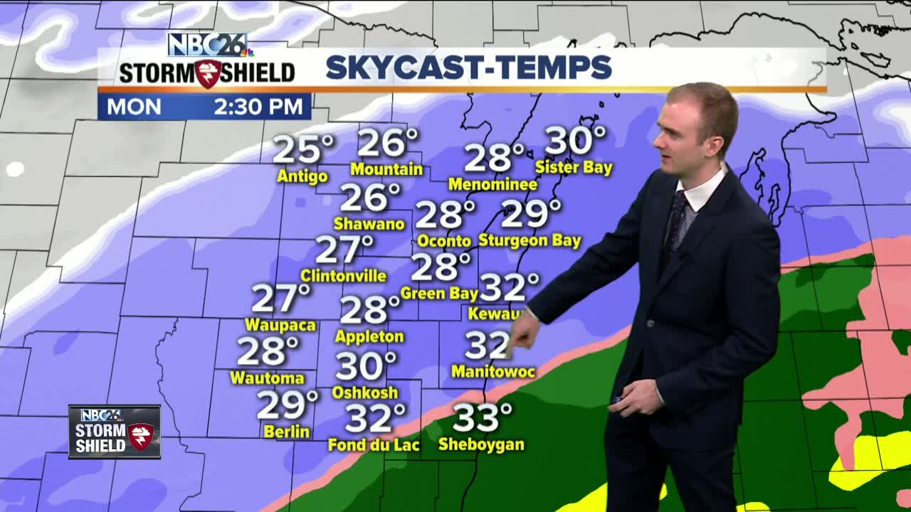
Temperatures will dip into the mid and lower 20s tonight with partly cloudy to mostly cloudy skies. Winds will be out of the south at 5 to 10 mph. A big headache is ahead for anyone planning to head out and celebrate the upcoming new year with several inches of snow on the way. Two low pressure systems will join together into one larger system tomorrow afternoon. Starting off in the day, skies will be mostly cloudy as temperatures rise into the lower and mid 30s. Initially, a wintry mix will begin for areas along and south from Oshkosh to Manitowoc. Some sleet and freezing rain will persist for those areas from noon until 3 or 4 pm. The farther south you live towards Sheboygan, the longer the wintry mix will last towards that 3 to 4 pm time. Further north, precipitation will begin and last throughout the entire event in the form of snowfall. The peak of the snow storm will be during the afternoon into the evening. Snow will turn light after 9pm and linger into flurries or a few light snow showers by midnight. A couple light snow showers and flurries will last into early Tuesday morning before high pressure moves in. Total snowfall accumulation will be 2 to 5 inches for almost everyone with some localized areas near a half foot of snow. The exception will be our northern counties of Marinette, Menominee, Langlade, and Oconto. There will be a sharp gradient where snow accumulation will turn to just a few flurries. The southern parts of these counties will have 1 to 3 inches of snow. The northern section will have only a dusting at most. Afterwords, the pattern turns somewhat quiet. There are a few weak clippers that will move through some parts of the Midwest but right now they appear to pass north of our area. Temperatures will fluctuate between the teens on Wednesday with a slow gradual warming trend into the mid and upper 30s by the weekend.
-
 1:45
1:45
WGBA
1 year agoFond du Lac Cardinals start the football season with a new $5.3 million nest
367 -
 4:18
4:18
WGBA
4 years agoGino Recchia NBC26 Weather Forecast
11 -
 3:47
3:47
WGBA
4 years agoGino Recchia NBC26 Weather Forecast
1 -
 3:32
3:32
WGBA
4 years agoGino Recchia NBC26 Weather Forecast
6 -
 4:26
4:26
WGBA
4 years agoGino Recchia NBC26 Weather Forecast
1 -
 3:43
3:43
WGBA
4 years agoGino Recchia NBC26 Weather Forecast
3 -
 4:06
4:06
WGBA
4 years agoGino Recchia NBC26 Weather Forecast
4 -
 3:28
3:28
WGBA
4 years agoGino Recchia NBC26 Weather Forecast
5 -
 3:58
3:58
WGBA
4 years agoGino Recchia NBC26 Weather Forecast
1 -
 3:55
3:55
WGBA
4 years agoGino Recchia NBC26 Weather Forecast
1