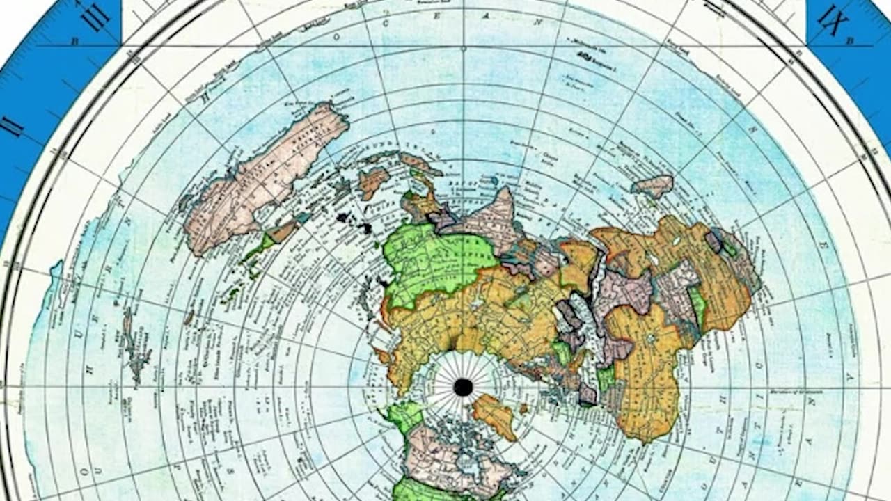
Flat Earth Map FAILS the Polaris Test — Again, the Globe Wins
I printed a 4-foot Gleason’s map to see if Polaris angle measurements actually work on a Flat Earth model. Spoiler: they don’t. Not even close.
I used real-world data from cities like New York, Santiago, and the Equator, then compared their Polaris angles using pins and protractor measurements. Whether Polaris is 3,000 miles high, 500 miles, or somewhere in between, it just doesn’t work on the flat map.
🧭 Meanwhile, the globe?
Perfectly consistent. Just like sailors used it for centuries before GPS.
Here’s what I measured:
North Pole to Quebec = ~3,000 mi
NY to Polaris = ~36° (should be ~43°)
Equator to Polaris = 23° to 30° (should be 0°)
Santiago to Polaris = 6–21°, depending on height
Polaris height adjustments? Still broken.
You can’t fake celestial navigation. And you can’t fix this map.
Try it yourself. Show me a working flat model. Or admit that Polaris destroys it.
-
 LIVE
LIVE
Matt Kohrs
8 hours agoStocks Hit Record High, Breaking Jobs News || Live Day Trading & Analysis
794 watching -
 LIVE
LIVE
Wendy Bell Radio
5 hours agoSchilling For Big Pharma
7,418 watching -
 1:09:42
Crypto Power Hour
2 hours agoMemecoin Masterclass
2.08K4 -
 LIVE
LIVE
Major League Fishing
1 day agoLIVE Tackle Warehouse Invitationals Championship, Day 1
1,135 watching -
 LIVE
LIVE
LFA TV
3 hours agoLFA TV ALL DAY STREAM - FRIDAY 9/5/25
3,918 watching -
 1:49:27
Game On!
19 hours ago $3.30 earnedIt's A FOOTBALL Friday! NFL In Brazil! Chiefs vs Chargers Preview!
34.7K1 -
 LIVE
LIVE
JuicyJohns
1 hour ago $0.34 earned🟢#1 REBIRTH PLAYER 10.2+ KD🟢
69 watching -
 14:31
14:31
Adam Does Movies
14 hours ago $3.20 earnedAlien: Earth Episode 5 - Recrap
45.5K2 -
 12:54
12:54
Michael Button
19 hours ago $3.06 earnedWhat If We’re Just the Most Recent Civilization?
20.9K16 -
 1:15:19
Surviving The Survivor: #BestGuests in True Crime
2 days agoDonna Adelson's Defense Witnesses Get Caught Up on Stand; Will Jurors Believe Them?
10.4K