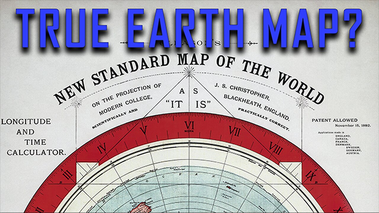
Testing the Gleason Map Using Real Sunlight Data | Does It Actually Work?
Flat earthers claim the Gleason map is the real map of the Earth — a pure, distortion-free version of reality that NASA supposedly doesn't want you to see.
But what happens when we test that map using actual sunrise and sunset data, direct sun observations, and basic geometry? It falls apart — fast.
In this video, I use December 21st (the winter solstice) to compare Oulu, Finland and Cape Town, South Africa — two cities nearly aligned longitudinally, but in opposite hemispheres. Using verified data from dateandtime.com, I show the exact sunrise and sunset times for both cities and determine the geographic position (GP) of the sun at each moment.
Then, I plot those sun positions on the Gleason map — the flat Earth model that’s plastered across TikTok, Rumble, and YouTube. What we discover is hilarious and undeniable:
Finland only sees the sun when it’s near southern Africa…
Cape Town sees the sun even when it’s farther from the sun’s ground position.
On the Gleason map, this makes zero sense. On the globe? It lines up perfectly.
I also show a real-time video of Earth’s rotation, demonstrating why Cape Town gets 14+ hours of daylight while Finland barely sees the sun. This isn’t theoretical. This is visible reality — and it debunks the Gleason map with eyes-on-the-sun accuracy.
🔍 Topics covered:
Flat Earth debunk using sunlight
Gleason map disproven
How sunrise/sunset proves a globe
Cape Town vs Finland sunlight experiment
Sun GP visualization
Flat Earth TikTok/YouTube misinformation
🌐 No CGI. No satellites. Just sunlight and basic logic.
📌 Like and subscribe if you enjoy these breakdowns.
💬 If you're a flat earther with a better explanation — bring it.
Otherwise? Chalk this up as another Flat Earth FAIL.
-
 LIVE
LIVE
Side Scrollers Podcast
2 hours agoStreamer KICKED OUT of Renaissance Fair for Misgendering + Spiderman MELTDOWN | Side Scrollers Live
359 watching -
 LIVE
LIVE
Viss
1 hour ago🔴LIVE - Learn How To Dominate The Solo Battleground - PUBG
83 watching -
 LIVE
LIVE
Sean Unpaved
1 hour agoFumbles, Flubs, & Loogies: NFL Opener Chaos
139 watching -
 LIVE
LIVE
The Shannon Joy Show
1 hour ago🔥🔥Friday Freestyle! - MAGA Erupts Over Trump-Gates Bromance🔥🔥
172 watching -
 1:39:38
Steven Crowder
4 hours agoIndia First! MAGA Influencers Caught Pushing Insanely Stupid Propaganda
188K141 -
 LIVE
LIVE
IrishBreakdown
2 hours agoNotre Dame Football Mailbag
33 watching -
 LIVE
LIVE
The Drew Allen Show on DailyClout
2 hours ago"Trump DOJ Turns Democrats Into Gun Lovers"
58 watching -
 1:00:39
The Rubin Report
3 hours agoIt’s Official: Border Czar Names the Four Blue Cities Trump Will Target Next
37.5K17 -
 1:13:22
The Mel K Show
2 hours agoMORNINGS WITH MEL K - Clown Show in DC RFK Jr. Hearing Prove We the People are the Only Answer 9-5-25
19.8K16 -
 LIVE
LIVE
Film Threat
19 hours agoTHE CONJURING: LAST RITES + SPLITSVILLE + TONS OF REVIEWS! | Film Threat Livecast
84 watching