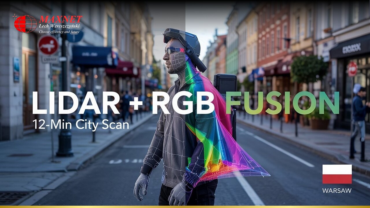
LiDAR and RGB fusion: Scanning Poleczki Street in Warsaw in 12 minutes
The mobile laser scanning of Poleczki Street in Warsaw took just 12 minutes. A FJD Trion S1 system in a backpack configuration was used, which combines data from a LiDAR scanner with images from a 72 MPix RGB camera. This technology made it possible to obtain precise elevation data and visually rich object textures.
The LiDAR point cloud, although sparser than in photogrammetry, has an elevation accuracy of 2 cm. The RGB camera provides detailed textures and colors to help identify objects. Fusion of the two datasets is done in real time in FJD's Trion Model software. The operator can switch the view between the point cloud and the RGB image on the fly to quickly resolve doubts about the nature of objects.
Hybrid viewing is one of the biggest advantages of this technology. When the LiDAR cloud fails to distinguish details (e.g., a manhole from a drainpipe), the RGB image provides the missing information. This avoids interpretation errors for the operator and saves time on later data analysis.
During the scanning of Poleczki Street, the system recorded data on pavement, road infrastructure and urban greenery. Combining LiDAR with the visual context of the camera made it possible to create a complete 3D model. Such a model is ready for further analysis in CAD or BIM programs without the need for additional postprocessing.
-
 LIVE
LIVE
Redacted News
32 minutes agoThe FBI's Charlie Kirk assassination story has fully collapsed as new details emerge | Redacted News
23,452 watching -

vivafrei
2 hours agoLive with The Blaze's Steve Baker: Jan. 6 Fed-Surrection and Patel's Clarification Adds Confusion!
46.5K10 -
 LIVE
LIVE
Dr Disrespect
4 hours ago🔴LIVE - DR DISRESPECT - BABY STEPS - TO THE TIPPITY TOP
1,834 watching -
 LIVE
LIVE
Futures Edge: Finance Unfiltered with Jim Iuorio and Bob Iaccino
1 hour agoSeptember Surge: What It Means for Q4
226 watching -
 1:41:57
The Quartering
2 hours agoMotive In Church Attack Revealed, Dangerous Walmart Food Kills, Eric Adams Out & More
105K17 -
 LIVE
LIVE
The Trish Regan Show
1 hour agoBREAKING: NFL Picks Anti-Trump Rapper Bad Bunny for Super Bowl—Risking MASSIVE Fan Boycott!
351 watching -
 45:18
45:18
Stephen Gardner
2 hours ago🚨EXPOSED: Real reason Trump preparing for war - Tulsi Gabbard WARNS Trump!!
2.67K24 -
 4:23:04
Right Side Broadcasting Network
7 hours agoLIVE REPLAY: President Trump Participates in a Press Conference With Prime Minister Netanyahu - 9/29/25
66.8K36 -
 1:09:19
The White House
5 hours agoPresident Trump Participates in a Bilateral Meeting with the Prime Minister of the State of Israel
11.6K27 -
 1:25:35
Russell Brand
3 hours agoMichigan Church Shooting Sparks Trump Warning Of ‘TARGETED ATTACK On Christians’ - SF641
151K43