Gino Recchia NBC26 Storm Shield Weather Forecast
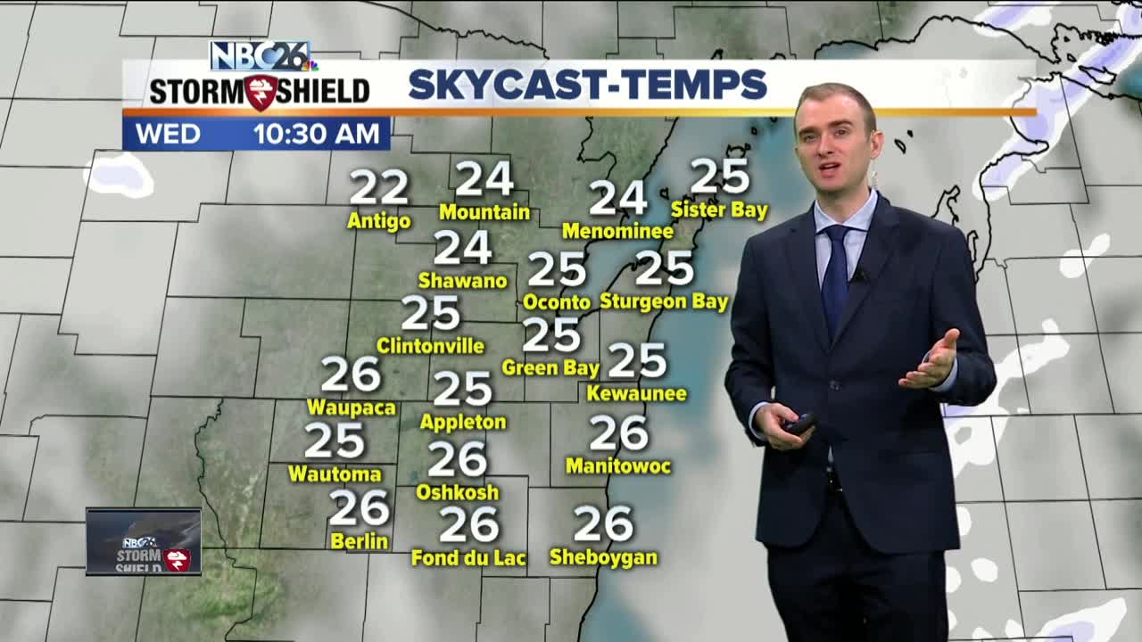
Cool weather continues to hold its grasp across the Midwest and it is going to get even colder in the coming days. Today will a bit cool with highs in the upper 20s and lower 30s with winds out of the west and southwest between 5 and 15 mph. Skies will be mostly cloudy to overcast during the day and we are also tracking some snow showers to the area later this afternoon and evening ahead of an arctic front. Snowfall accumulation will be very minimal, a dusting at most. Winds will shift out of the west and northwest around 10 to 15 mph behind the cold front with temperatures dipping into the mid and upper teens. Thursday will be cooler with another slight chance of a passing snow shower or a few flurries. Highs will be in the mid 20s with winds out of the northwest around 10 to 15 mph. Thursday night is when our temperatures take a dive into the single digits, both potentially above and below zero. This will be the coldest airmass to infiltrate our area so far this season as a strong arctic high pressure moves in. High temperatures on Friday currently projected to be in the mid teens, the coldest high since last February. The good news is that we go into a gradual warming trend as we head into the weekend and into next week with an abundance of sunshine.
-
 1:57
1:57
WGBA
1 year agoHow the City of Green Bay is hoping a $1.6M investment will make the community safer for pedestrians
4682 -
 3:40
3:40
WGBA
4 years agoGino Recchia NBC26 Weather Forecast
5 -
 3:21
3:21
WGBA
4 years agoGino Recchia NBC26 Weather Forecast
3 -
 3:51
3:51
WGBA
4 years agoGino Recchia NBC26 Weather Forecast
1 -
 2:32
2:32
WGBA
4 years agoGino Recchia NBC26 Weather Forecast
6 -
 3:45
3:45
WGBA
4 years agoGino Recchia NBC26 Weather Forecast
14 -
 3:07
3:07
WGBA
4 years agoGino Recchia NBC26 Weather Forecast
9 -
 3:44
3:44
WGBA
4 years agoGino Recchia NBC26 Weather Forecast
8 -
 3:48
3:48
WGBA
4 years agoGino Recchia NBC26 Weather Forecast
-
 3:13
3:13
WGBA
4 years agoGino Recchia NBC26 Weather Forecast
63