Gino Recchia NBC26 Storm Shield Weather Forecast
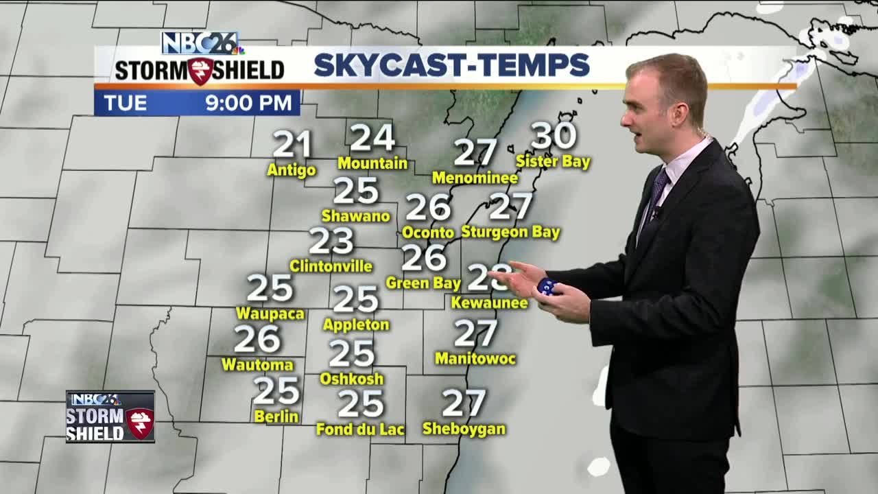
The forecast is remaining rather quiet over the coming days here in Northeast Wisconsin. High pressure has a small influence in our weather but with it moving to the Southern Plains, its far position from us will keep the mostly cloudy skies intact today. High temperatures will be in the upper 20s with winds out of the west and southwest between 5 to 10 mph. Tonight we cool down into the upper teens with mostly cloudy skies and winds out of the west and southwest between t to 10 mph. Wednesday will be an almost carbon copy, highs in the upper 20s and winds out of the west and southwest around 5 to 10 mph. On Thursday, an arctic front will move through the Midwest and bring a chance of a few flurries. Now behind the front, winds will begin to pick out of the northwest with gusts perhaps upward of 25 mph. The stronger northerly winds are being accompanied by an arctic high pressure which is going to drop our high temperatures down into the Teens Friday, the coldest high of the week. Temperatures slowly rebound going into the weekend, gradually warming into the mid and upper 20s with mostly sunny skies both days.
-
 3:36
3:36
WGBA
1 year agoWill it be necessary to have both the AC & the heat on during the same day??
3831 -
 3:40
3:40
WGBA
4 years agoGino Recchia NBC26 Weather Forecast
5 -
 3:21
3:21
WGBA
4 years agoGino Recchia NBC26 Weather Forecast
3 -
 3:51
3:51
WGBA
4 years agoGino Recchia NBC26 Weather Forecast
1 -
 2:32
2:32
WGBA
4 years agoGino Recchia NBC26 Weather Forecast
6 -
 3:45
3:45
WGBA
4 years agoGino Recchia NBC26 Weather Forecast
14 -
 3:07
3:07
WGBA
4 years agoGino Recchia NBC26 Weather Forecast
9 -
 3:44
3:44
WGBA
4 years agoGino Recchia NBC26 Weather Forecast
8 -
 3:48
3:48
WGBA
4 years agoGino Recchia NBC26 Weather Forecast
-
 3:13
3:13
WGBA
4 years agoGino Recchia NBC26 Weather Forecast
63