Gino Recchia NBC26 Storm Shield Weather Forecast
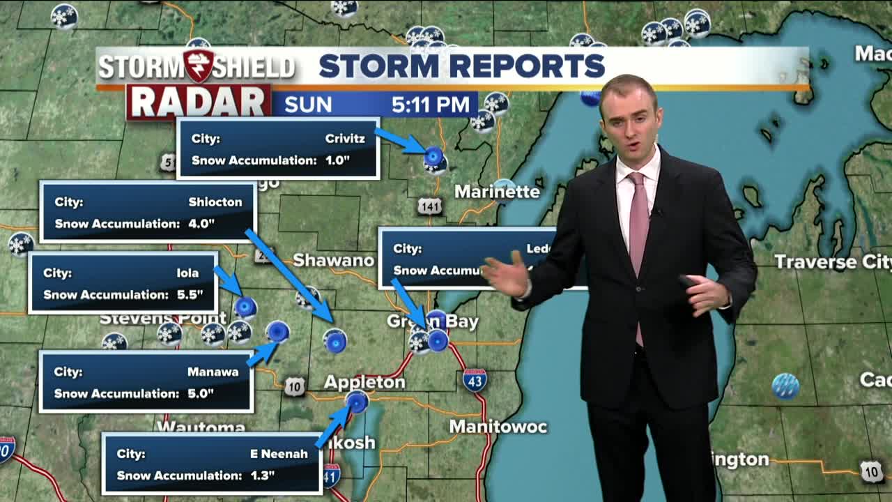
It is not the typical snow storm that you would expect in Northeast Wisconsin, but given the early start to the winter season, nothing is surprising. Waves of snowfall moves in last night and continued through this afternoon. Winter weather advisories are in place until 9 PM but with snow showers expected to weaken and move out of hte area sooner, these advisories will likely be canceled ahead of time. The highest snowfall totals were measured in Waupaca county, with 5 to 6 inches of snow, Shiocton in Outagamie had 4 inches, and in Green Bay, around 2.5 to 3 inches. These snowfall reports were measured in the morning but temperatures in the afternoon rose above freezing snow the snowfall was melting. Temperatures are going to drop with gusty winds tonight, upper 20s with north winds around 15 to 20 mph with higher gusts possible. Mostly cloudy skies will stick around for our Monday with highs right around freezing with winds out of hte north and northwest between 5 to 15 mph. Tuesday will be cooler with highs in the upper 20s under mostly cloudy skies but winds will be lighter out of the west around 5 to 10 mph. A little bit more sunshine returns for Wednesday with mid 20s under partly cloudy skies. On Thursday there is a weak clipper that will pass through the Midwest. A few flurries or a snow shower will pass through with temperatures in the mid 20s. Behind this clipper, some chilly air will move in for Friday and Saturday, temperatures running ten to fifteen degrees below normal with highs in the teens and lower 20s, but at least skies will be mostly sunny.
-
 1:45
1:45
WGBA
1 year agoStudents excited to start at "huge and beautiful" Vel Phillips Middle School
387 -
 3:40
3:40
WGBA
4 years agoGino Recchia NBC26 Weather Forecast
5 -
 3:21
3:21
WGBA
4 years agoGino Recchia NBC26 Weather Forecast
3 -
 3:51
3:51
WGBA
4 years agoGino Recchia NBC26 Weather Forecast
1 -
 2:32
2:32
WGBA
4 years agoGino Recchia NBC26 Weather Forecast
6 -
 3:45
3:45
WGBA
4 years agoGino Recchia NBC26 Weather Forecast
14 -
 3:07
3:07
WGBA
4 years agoGino Recchia NBC26 Weather Forecast
9 -
 3:44
3:44
WGBA
4 years agoGino Recchia NBC26 Weather Forecast
8 -
 3:48
3:48
WGBA
4 years agoGino Recchia NBC26 Weather Forecast
-
 3:13
3:13
WGBA
4 years agoGino Recchia NBC26 Weather Forecast
63