Gino Recchia NBC26 Storm Shield Weather Forecast
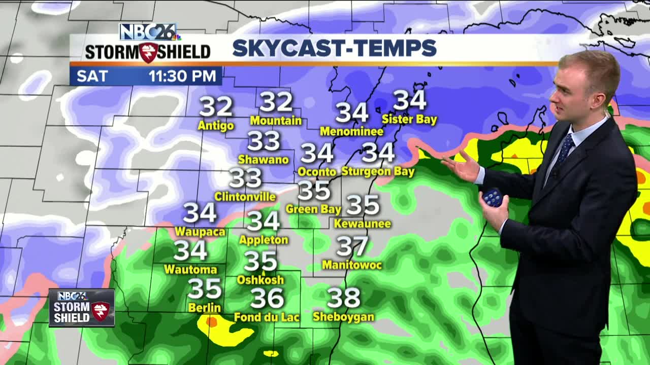
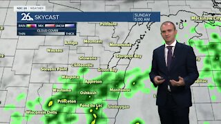
Another early season snow storm is targeting this Midwest and this weekend it is affecting Northeast Wisconsin, parts of the area that is. A large area of low pressure is slowly stalling out over the Central Plains while it continues to send round of precipitation into the Midwest. Ths storm system is strong enough to even produce some tornado in Central Illinois. Right now it looks like the cut off line between rain and snow will be from Wautoma through Appleton, Green Bay and Sturgeon Bay. Areas south of this line will see more rain than snow. Areas north of this line will see more snow than rainfall. Not only is this storm tricky with positioning the rain/snow line, but also with it being a long duration event and temperatures not too conducive for accumulations, the snow that falls will likely be melting for most of us. To compensate the melting, snow rates will have to be high to accumulate on the ground. Winter weather advisories have been issued for all counties except Green Lake, Marquette, Fond Du Lac, Sheboygan, and Manitowoc Counties. The advisories continue until the afternoon tomorrow. Snowfall totals by the afternoon will be between 3-6 inches with some areas seeing near 7 inches of snow for areas north of a line from Wautoma to Green Bay. Along this line, 2-4 inches, south of this line, a dusting to an inch. The snowfall will be very wet and heavy so expect a lot of compaction. Winds will be very strong as well out of the northeast around 15 to 25 mph with gusts bear 35 to 40 mph. This will cause snow to blow but I don't expect much drifting expect along structures where wind vortices are common.
-
 0:30
0:30
WGBA
1 year agoThree Degree Guarantee
369 -
 3:40
3:40
WGBA
4 years agoGino Recchia NBC26 Weather Forecast
5 -
 3:21
3:21
WGBA
4 years agoGino Recchia NBC26 Weather Forecast
3 -
 3:51
3:51
WGBA
4 years agoGino Recchia NBC26 Weather Forecast
1 -
 2:32
2:32
WGBA
4 years agoGino Recchia NBC26 Weather Forecast
6 -
 3:45
3:45
WGBA
4 years agoGino Recchia NBC26 Weather Forecast
14 -
 3:07
3:07
WGBA
4 years agoGino Recchia NBC26 Weather Forecast
9 -
 3:44
3:44
WGBA
4 years agoGino Recchia NBC26 Weather Forecast
8 -
 3:48
3:48
WGBA
4 years agoGino Recchia NBC26 Weather Forecast
-
 3:13
3:13
WGBA
4 years agoGino Recchia NBC26 Weather Forecast
63