🇷🇺 🏹 🎣 Kupyansk Direction — Rybar’s Analysis
The following text constitutes the official English translation.
📝Kupyansk Direction - Rybar's Analysis
Systematic Advance to the West
The primary military confrontations in the area have been documented along the right bank of the Oskol River and in the central sector near Stepovaya Novoselovka. Conversely, the southern flank is marked by a paucity of information from both belligerent parties.
The following section will provide a more thorough examination of the chronology of battles in the area.
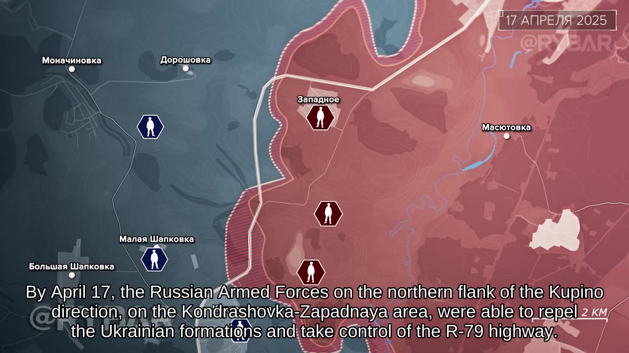
By April 13, Russian troops had advanced beyond the forest belt, pushing the enemy back north of Stepovaya Novoselovka. However, they had not yet secured the settlement itself.
By April 17, the Russian Federation's (RF) Armed Forces had advanced towards the outskirts of Doroshovka, effectively securing control of the section of the R-79 road. This development followed the displacement of Ukrainian formations from the area around Zapadnoye.
Moreover, the combatants successfully widened the bridgehead on the right bank of the Oskol. Their advance proceeded in the residential area of Kamenka, situated to the northeast.
In the vicinity of Kupyansk, Russian military personnel are advancing westward, engaging in combat operations in the areas of Malaya Shapkovka and Kondrashovka.
In the event of a further advance of Russian troops towards Kupyansk from the Kolesnikovka–Stepovaya Novoselovka line, it is anticipated that it will become quite challenging for Ukrainian formations to maintain their positions in the Novoosinovo and Petropavlovka areas. Despite the presence of numerous fortified areas, this development will result in a substantial weakening of the defensive order of the Armed Forces of Ukraine.
#video #digest #map #Kupyansk #Russia #Ukraine #Kharkov
#video #analysis
#summary #broadcasts
#Russia #Ukraine #War #Rybar #Video
#RussianSpecialMilitaryOperation #Russia #Ukraine #MilitaryAction
-
 LIVE
LIVE
JuicyJohns
1 hour ago🟢#1 REBIRTH PLAYER 10.2+ KD🟢
79 watching -
 18:22
18:22
World2Briggs
20 hours ago $2.63 earnedThe New York Rant: Point Blank With No Fluff or BS. A Warning
11.7K7 -
 42:52
42:52
The Finance Hub
15 hours ago $3.08 earnedBREAKING: ALINA HABBA JUST SHOCKED THE WORLD!
10.5K30 -
 2:00:44
BEK TV
1 day agoTrent Loos in the Morning - 8/26/2025
13.4K -
 12:15
12:15
Nikko Ortiz
19 hours agoMonday Gun Fails
69.7K16 -
 8:19
8:19
MattMorseTV
18 hours ago $12.36 earnedTrump is ACTUALLY DOING IT.
68.9K54 -
 5:40
5:40
Sugar Spun Run
1 day ago $1.13 earnedNutella Brownies
20.3K2 -
 8:46
8:46
Faith Frontline
17 hours agoBill Maher STUNNED as Charlie Kirk Proves God Exists
22K19 -
 LIVE
LIVE
FyrBorne
11 hours ago🔴Warzone M&K Sniping: On the Hunt For The Next Fun Builds
132 watching -
 7:11
7:11
MudandMunitions
14 hours agoNY Legal, Still LETHAL! Colt M4 + Griffin Armament GPS3X Prism Sight! NIGHT SHOOT
13.9K3