⚠️ Significant Tornado Risk Today: Enhanced Severe Threat! April 5
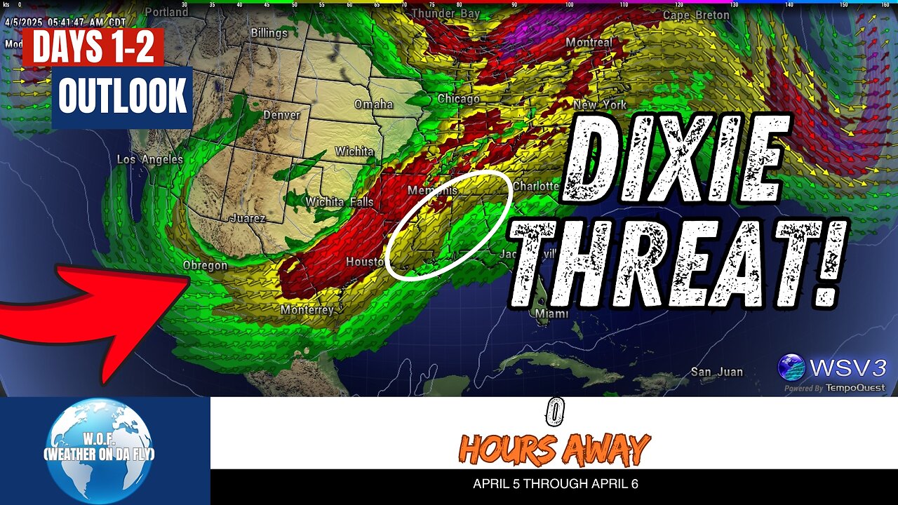
⚠️ Stay weather-aware today with W.O.F. (Weather On da Fly)! An enhanced risk of severe thunderstorms is in place from the lower Sabine River Valley to the Tennessee Valley this Saturday, April 5, 2025. Strong tornadoes, large hail, and damaging winds are possible, with powerful supercells expected along the frontal zones. Environmental conditions, including high instability and strong shear, are setting the stage for a volatile weather day.
Looking ahead to Sunday, isolated severe storms could impact parts of the Southeast and southern Appalachians. While strong shear may support storm organization, weakening instability might limit the overall severe threat. Stay tuned for updates on the latest NOAA and SPC outlooks as we track these systems.
Your #1 Source for quick Severe/Tropical Weather Outlooks & Discussions, W.O.F. (Weather On da Fly) keeps you informed with the latest forecasts from the tropics to the heartland. Don’t miss a beat—#Share, #Like, and #Subscribe for more updates on tornado risks, hurricane season, and crucial weather alerts this April 2025! 🌪️🌦️ #Weather #Outlook #SPC #NOAA #Tropics
#weatherupdatetoday #tornado #severestormthreat #damagingwinds #storm
CHAPTERS:
00:00 - Severe Weather Outlook Today
00:08 - Convective Outlook Day 1
01:46 - Convective Outlook Day 2
03:33 - Share, Like & Subscribe
-
 LIVE
LIVE
Kim Iversen
2 hours agoTrump Threatens To End ALL Support For Israel
2,713 watching -
 15:38
15:38
Cash Jordan
2 hours agoPortland Zombies EMPTY 52 Stores… Mayor FREAKS as “Sanctuary” SELF DESTRUCTS
2.17K9 -
 1:56:46
Redacted News
2 hours agoHIGH ALERT! Trump pushes "land war" in Venezuela, and Russia goes nuclear | Redacted News Live
94.3K46 -
 16:47
16:47
Robbi On The Record
1 hour ago $0.04 earnedThe Day Seeing Stopped Meaning Believing | Sora, AI and the Uncanny Valley
23 -
 9:54
9:54
Dr. Nick Zyrowski
1 day agoDoctors Got It Wrong! What High Cholesterol REALLY Means...
8623 -
 LIVE
LIVE
Tundra Tactical
1 hour agoProfessional Gun Nerd Plays Battlefield 6
76 watching -
 1:06:06
vivafrei
3 hours agoAnother Illegal Alien Kills Americans! Candace Owens Promises to Violate Kirk Gag Order? & MORE!
107K25 -
 1:42:30
The Quartering
4 hours agoTrump Blamed For NBA Rigging Scandal, Major X Change Renders Site Useless, Church Nonsense
132K36 -
 4:18:11
MattMorseTV
6 hours ago $48.22 earned🔴Trump makes URGENT ANNOUNCEMENT.🔴
75.3K69 -
 12:05
12:05
Clintonjaws
9 hours ago $9.23 earnedPortland ICE Rioters Getting Arrested - This Is Priceless!
44.6K21