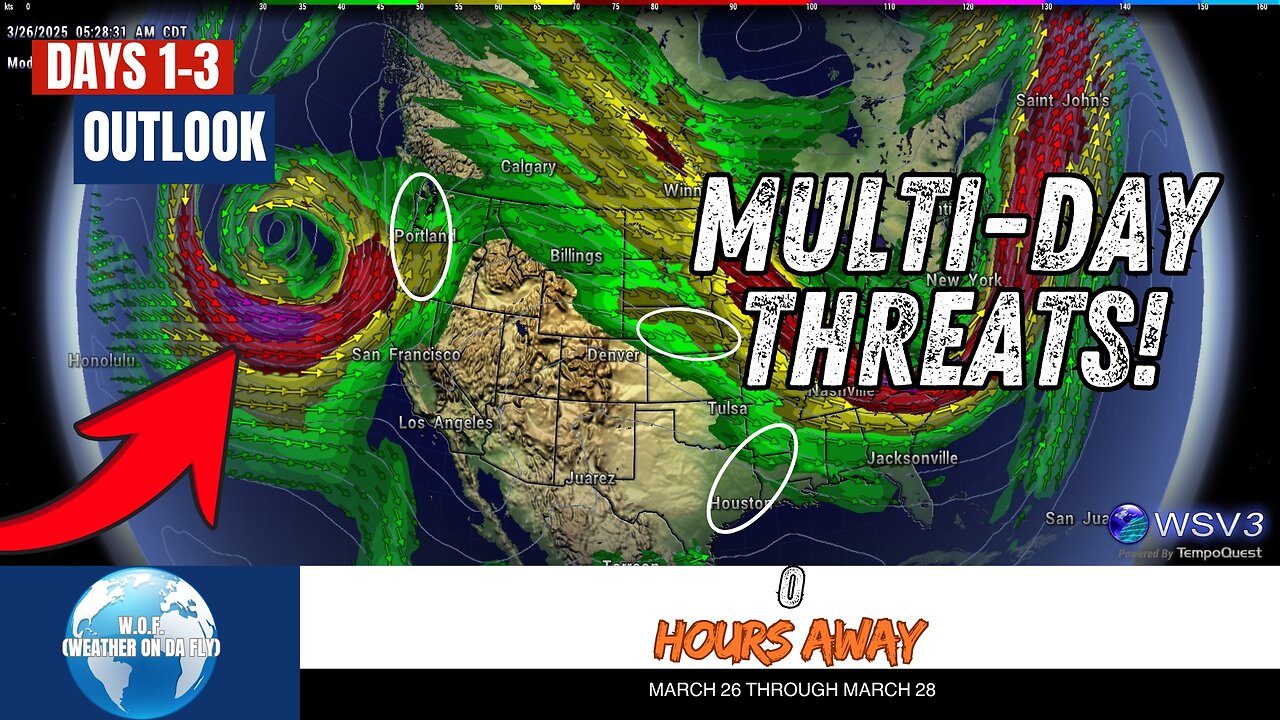
⚠️ Supercells & Tornado Risk Today: Pacific Northwest Alert! March 26
⚠️ Supercells & tornado risk alert for the Pacific Northwest today! Stay informed with W.O.F. (Weather On da Fly), your #1 source for quick Severe/Tropical Weather Outlooks & Discussions. Today’s weather forecast highlights a slight risk for severe thunderstorms across the Pacific Northwest with supercells expected west of the Cascades in Oregon and Washington. Large hail, strong gusts, and even a brief tornado are possible, so stay prepared. Meanwhile, a flash flood threat may develop in the Lower Rio Grande Valley.
Looking ahead, severe weather risks extend into Southern Texas on Thursday, featuring hail, gusty winds, and potential rotating storms. By Friday, thunderstorms with hail and gusty winds could impact regions from Eastern Texas to the Lower Mississippi Valley and Nebraska. With boundary layer moisture rising and dynamic atmospheric conditions in play, these storms may intensify quickly.
For the latest from SPC, NHC, and NOAA on severe weather, tropical outlooks, and more, count on W.O.F. (Weather On da Fly)! Don’t forget to #Share, #Like, and #Subscribe to stay ahead of tornadoes, hurricanes, and all things weather this March 2025. 🌪️🌧️☀️
CHAPTERS:
00:00 - Intro
00:10 - Convective Outlook Day 1
01:25 - Convective Outlook Day 2
03:43 - Convective Outlook Day 3
-
 12:11
12:11
Nikko Ortiz
2 days agoCrashout 6 Rumble
88.1K8 -
 19:56
19:56
GritsGG
14 hours agoSpectating Random Solo Players in a Bot Lobby!
7.28K1 -
 LIVE
LIVE
Lofi Girl
2 years agoSynthwave Radio 🌌 - beats to chill/game to
423 watching -
 16:22
16:22
BlabberingCollector
2 days agoHarry Potter HBO: Addressing Some New Rumors!
6.91K3 -
 4:01:30
Badlands Media
22 hours agoThe Narrative Ep. 37: The Sovereign War
183K35 -
 11:23:54
SpartakusLIVE
14 hours agoMega SOLO Spartan Stream - 12 hours?! HA || Variety Later?!
108K1 -
 4:55:23
Rallied
7 hours ago $22.01 earnedSolo Warzone Challenges All Night
55.1K3 -
 4:53:38
Due Dissidence
17 hours agoTaibbi DEFENDS Weiss-CBS Deal, Pakman Producer SPILLS TEA, Massie CALLS OUT Trump Informant Claims
36.3K47 -
 2:33:47
TheSaltyCracker
10 hours agoMedia Silent on Metro Attack ReeEEStream 9-07-25
156K304 -
 56:27
56:27
Sarah Westall
11 hours agoEnd of Aging, Hydrogen Bomb Research, Serial Killers & Violent Behavior, Bipolar Research w/Dr Walsh
43.4K6