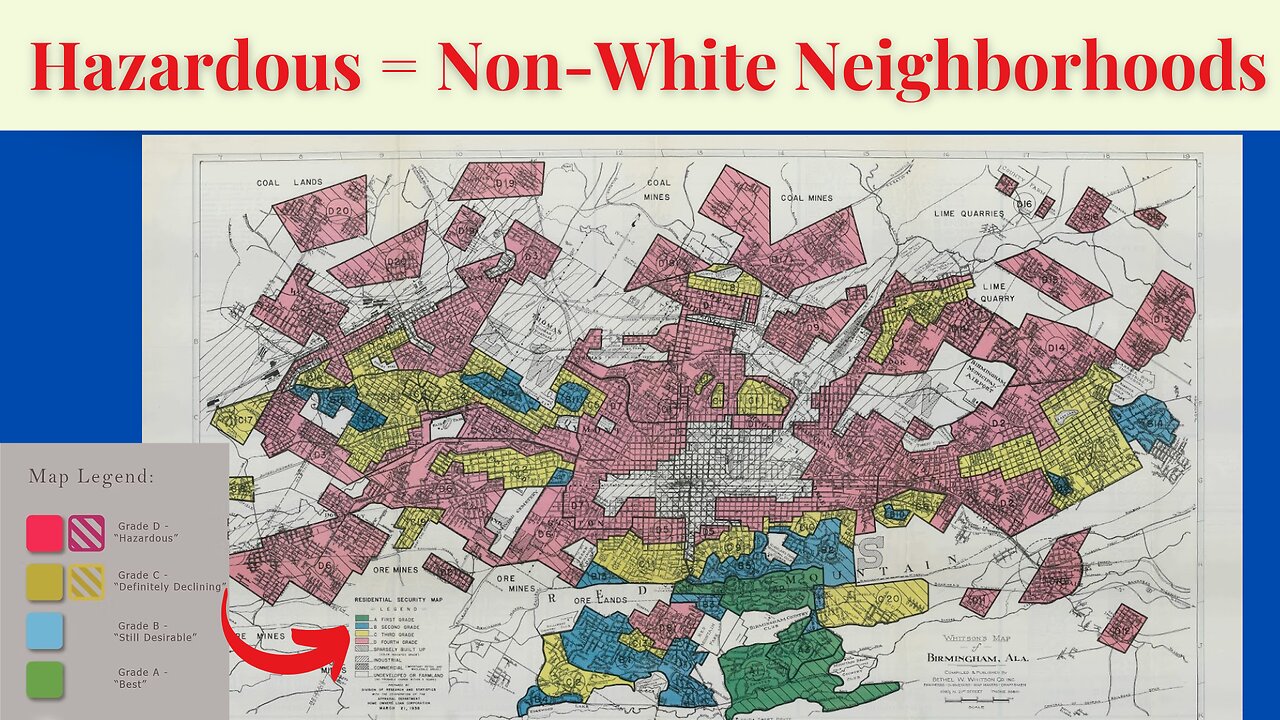
Breaking Down Birmingham's Redlining Map
The Home Owners' Loan Corporation (HOLC) created a residential security map for Birmingham, Alabama, as part of its redlining practices in the 1930s. These maps categorized neighborhoods into four grades:
"A" (Green) – Considered the "best" areas, primarily white, middle- to upper-class neighborhoods with strong investment potential.
"B" (Blue) – "Still desirable" areas with stable housing but slightly lower property values.
"C" (Yellow) – "Declining" neighborhoods, often working-class areas with some racial and economic diversity.
"D" (Red) – "Hazardous" areas, largely Black and immigrant communities that were systematically denied mortgage lending and investment.
Birmingham’s redlined neighborhoods were concentrated in predominantly Black areas, particularly in parts of North Birmingham, Smithfield, and Ensley, which suffered from decades of disinvestment. These redlining maps directly contributed to the racial wealth gap, housing segregation, and economic disparities that persist today.
#redlining #birmingham #alabama #HOLC #MortgageDiscrimination #LendingDiscrimination
-
 LIVE
LIVE
Timcast
52 minutes agoTrump MOBILIZING National Guard In NATIONWIDE Crackdown
20,197 watching -
 LIVE
LIVE
Steven Crowder
3 hours ago🔴 Donald Trump Vs American Crime: Chicago is Next & Libs Are Freaking Out
24,833 watching -
 LIVE
LIVE
The Charlie Kirk Show
23 minutes agoChicago Next! + The Blue Slip Problem | Sen. Tuberville, Alex Clark | 8.25.2025
2,777 watching -
 DVR
DVR
Benny Johnson
2 hours ago🚨Trump LIVE Now: Signs Executive Order ENDING Cashless Bail | Dem Cities PANIC, Which City NEXT?...
14.5K22 -
 1:31:26
The White House
3 hours agoPresident Trump Signs Executive Orders, Aug. 25, 2025
6.6K12 -
 LIVE
LIVE
The Mel K Show
1 hour agoMORNINGS WITH MEL K - Starving the Globalist Funded Color Revolution in America 8-25-25
541 watching -
 LIVE
LIVE
The Shannon Joy Show
2 hours ago🔥🔥Stressflation Incoming - Coffee Up 25% Veggies Up 40% As Trumps Tariff Taxes Detonate On American Families.🔥🔥
166 watching -
 LIVE
LIVE
LFA TV
16 hours agoLFA TV ALL DAY STREAM - MONDAY 8/25/25
4,828 watching -
 UPCOMING
Grant Stinchfield
3 days agoDemocrats Try to Turn California Into Predator Playground with Proposed "Child Predator Dream Bill"
1.1K -
 1:01:13
VINCE
3 hours agoWhy Does This Mayor Enjoy Watching His City Burn? | Episode 110 - 08/25/25
130K91