NBC26 Storm Shield Weather Forecast
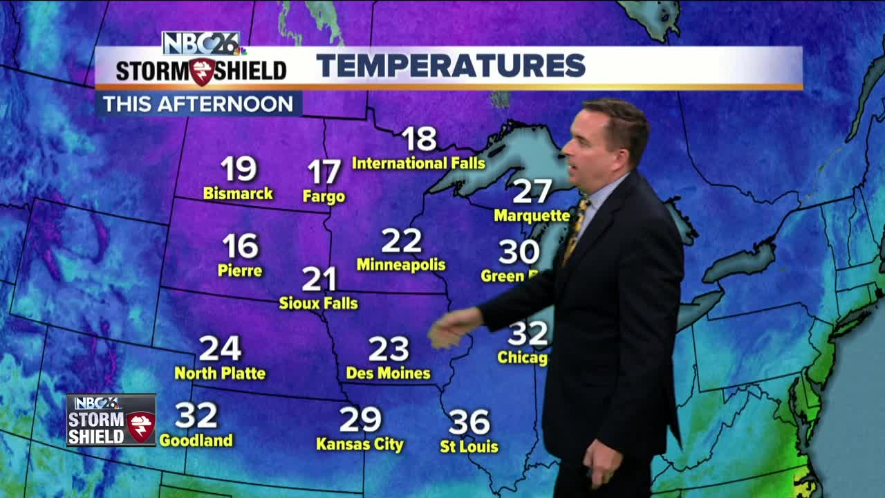
The first widespread accumulating snow of the season occurred on Friday & this early taste of Winter continues!! As the storm system responsible for the snow begins to lift out of the area this evening, another round of snow showers will return from the north. Another 1/2" to 1" will be possible with heavier snow showers. All snow showers should move out of the area by the early predawn hours of Saturday. Winds will be another main story with this storm system. West and northwest winds between 20 to 30 mph with gusts between 40 to possibly even 50 mph are likely overnight. Saturday will be mostly sunny & cold with highs in the upper 20s and lower 30s. Some light snow is possible Saturday night as a warm front moves through. Sunday calls for mostly cloudy skies and temperatures in the mid 30s with some passing flurries at times. The heart of this cold snap occurs on Monday & Tuesday with highs in the mid 20s to around 30.
-
 3:36
3:36
WGBA
1 year agoWill it be necessary to have both the AC & the heat on during the same day??
3771 -
 3:50
3:50
WGBA
4 years agoGino Recchia NBC26 Weather Forecast
4 -
 4:29
4:29
WGBA
4 years agoGino Recchia NBC26 Weather Forecast
3 -
 3:18
3:18
WGBA
4 years agoGino Recchia NBC26 Weather Forecast
8 -
 3:36
3:36
WGBA
4 years agoGino Recchia NBC26 Weather Forecast
7 -
 3:56
3:56
WGBA
4 years agoGino Recchia NBC26 Weather Forecast
3 -
 4:22
4:22
WGBA
4 years agoGino Recchia NBC26 Weather Forecast
3 -
 3:46
3:46
WGBA
4 years agoGino Recchia NBC26 Weather Forecast
8 -
 3:33
3:33
WGBA
4 years agoGino Recchia NBC26 Weather Forecast
3 -
 3:37
3:37
WGBA
4 years agoGino Recchia NBC26 Weather Forecast
4