Gino Recchia NBC26 Storm Shield Weather Forecast
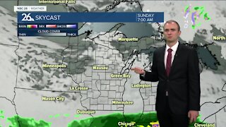
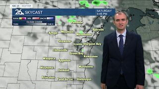
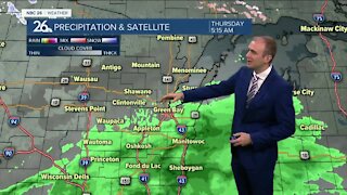
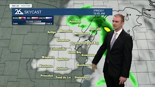
The weather across Northeast Wisconsin will remain quiet for another day or so before the risk of rain returns to the area. High pressure is moving over the Badger State so that is allowing temperatures to drop into the upper 20s and lower 30s on this Wednesday morning. Skies will remain mostly sunny through the day as we warm into the upper 40s with light winds out of the south and southeast around 5 mph. Tonight we will dip down into the lower 30s under mostly clear skies and light winds out of the southwest from calm to 5 mph. Clouds will be on the increase during the day Thursday ahead of our next storm system. By the late afternoon, skies will turn mostly cloudy to overcast with temperatures near 50 degrees. A slow moving and broad area of low pressure will bring the risk of rainfall from Friday through Sunday as temperatures fluctuate from the upper 40s to near 50 degrees. Rainfall estimates hover around a quarter to a half inch by late Sunday night. Dry weather will return for the beginning of the next week with temperatures in the lower 50s.
-
 1:57
1:57
WGBA
7 months agoHow the City of Green Bay is hoping a $1.6M investment will make the community safer for pedestrians
921 -
 3:31
3:31
WGBA
2 years agoGino Recchia NBC26 Weather Forecast
2 -
 3:37
3:37
WGBA
2 years agoGino Recchia NBC26 Weather Forecast
4 -
 3:30
3:30
WGBA
2 years agoGino Recchia NBC26 Weather Forecast
4 -
 3:41
3:41
WGBA
2 years agoGino Recchia NBC26 Weather Forecast
3 -
 3:17
3:17
WGBA
2 years agoGino Recchia NBC26 Weather Forecast
6 -
 3:01
3:01
WGBA
2 years agoGino Recchia NBC26 Weather Forecast
11 -
 3:28
3:28
WGBA
2 years agoGino Recchia NBC26 Weather Forecast
11 -
 3:02
3:02
WGBA
2 years agoGino Recchia NBC26 Weather Forecast
9 -
 3:10
3:10
WGBA
3 years agoGino Recchia NBC26 Weather Forecast
3