NBC26 Storm Shield Weather Forecast
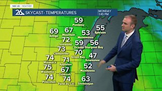
A warm front approaches late tonight ahead of the next low pressure system on the way. This could touch off a few showers/storms with lows actually rising from the lower-50s. After a lingering shower/storm during the morning with the warm front gusty SW winds will develop across the area boosting temps in the 70s & lower 80s. Dew point will be near 70° with a mix of sun & clouds. A cold front approaching late in the day will trigger more thunderstorms. We will have to keep an eye on the thunderstorms. Any storms that develop could be severe with all types of severe weather possible including tornadoes, damaging winds, hail & heavy rain. The cold front will sweep through Wednesday night with gusty NW winds & crashing temps. Thursday looks quiet and cooler with finally some sunshine and highs in the mid-50s. Rain rolls back in on Friday & continues on/off into next week. With this unusually active pattern to start the month, there is the potential for this October to be one of the wettest Octobers on record, and we're just getting started.
-
 0:30
0:30
WGBA
7 months agoThree Degree Guarantee
61 -
 3:52
3:52
WGBA
3 years agoGino Recchia NBC26 Weather Forecast
9 -
 3:10
3:10
WGBA
3 years agoGino Recchia NBC26 Weather Forecast
3 -
 3:51
3:51
WGBA
3 years agoGino Recchia NBC26 Weather Forecast
17 -
 3:34
3:34
WGBA
3 years agoGino Recchia NBC26 Weather Forecast
11 -
 4:01
4:01
WGBA
3 years agoGino Recchia NBC26 Weather Forecast
15 -
 3:11
3:11
WGBA
3 years agoGino Recchia NBC26 Weather Forecast
5 -
 3:33
3:33
WGBA
3 years agoGino Recchia NBC26 Weather Forecast
4 -
 3:45
3:45
WGBA
3 years agoGino Recchia NBC26 Weather Forecast
1 -
 4:02
4:02
WGBA
3 years agoGino Recchia NBC26 Weather Forecast
8