Michael Fish's NBC26 Storm Shield weather forecast
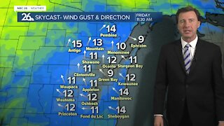
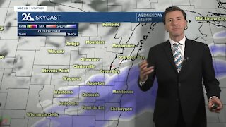
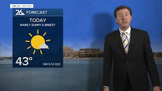
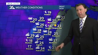
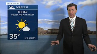
A cold front has dipped to our south and now stalled, and you'll notice the difference. It will be much cooler than it has been with highs only in the upper-60s to around 70 with plenty of clouds. There will be a slight chance of a shower or sprinkle mainly to the south, but a lot of the day should be okay. Tonight there will be a chance of a hit or miss shower or stray T'storm with lows in the mid-50s. Wednesday, a much stronger area of low pressure will be approaching the area slowly increasing our chances of a shower or T'storm as the day progresses. It'll be breezy with highs in the upper-60s. Wednesday night looks like it could be another soaker with locally heavy rainfall as the night wears on. Lows will be around 60. Thursday, that strong low pressure will be rolling through bringing parts of the area into the warm sector during the afternoon. After the morning showers move out, we'll have to see what redevelops in the afternoon. Anything that would could be strong to severe. Highs will top out around 80 with more humidity and windy conditions. That threat of strong to severe T'storms will continue into Thursday night with locally heavy rainfall possible. Friday, will be cooler and windy with partly cloudy skies.
-
 1:45
1:45
WGBA
11 months agoFond du Lac Cardinals start the football season with a new $5.3 million nest
204 -
 2:33
2:33
WGBA
3 years agoMichael Fish's NBC 26 weather forecast
4 -
 2:19
2:19
WGBA
3 years agoMichael Fish's NBC 26 weather forecast
3 -
 2:26
2:26
WGBA
3 years agoMichael Fish's NBC 26 weather forecast
4 -
 2:27
2:27
WGBA
3 years agoMichael Fish's NBC 26 weather forecast
4 -
 2:24
2:24
WGBA
3 years agoMichael Fish's NBC 26 weather forecast
3 -
 1:57
1:57
WGBA
3 years agoMichael Fish's NBC 26 weather forecast
2 -
 2:31
2:31
WGBA
3 years agoMichael Fish's NBC 26 weather forecast
7 -
 1:50
1:50
WGBA
3 years agoMichael Fish's NBC 26 weather forecast
4 -
 2:27
2:27
WGBA
3 years agoMichael Fish's NBC 26 weather forecast
1