SILENT PERSPECTIVES (4K) of National Wild & Scenic Upper Deschutes River | Bend | Central Oregon
Silent Perspectives of National Wild & Scenic Upper Deschutes River up and down the 8-Mile Shoreline Trail including Benham Falls, Dillon Falls, Upper Falls, Big Eddy etc. near Bend in Central Oregon! Each 4K Clip is original and no Clip appears twice.
In my opinion, there are about 8 Miles of PREMIUM River Shoreline Hiking on Deschutes River Trail along National Wild & Scenic Upper Deschutes River, Deschutes National Forest, Central Oregon.
This is EASILY a TOP 5 River Shoreline Hike in the Great State of Oregon! There are 3 Strategic Approaches to Capture/Tackle this EPIC area:
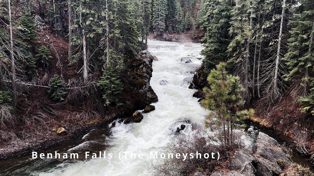
1) 8 Mile Point-to-Point Hike from Meadow Day Use Area to Sun-Lava Path Trailhead (called East Benham Falls Trailhead on Google Maps), in either Direction, need to arrange transportation at end of Hike!
2) 16 Mile Out & Back Hike from Meadow Day Use Area to Dillon Falls to Benham Falls to Sun-Lava Path Trailhead (called East Benham Falls Trailhead on Google Maps), in either Direction, no transportation logistics required, the Superstar Hiker Method!
3) Break Deschutes River Trail up into 2 separate more leisurely 8-Miles'ish Out & Back Hikes using Dillon Falls as the Midpoint:
a) Meadow Day Use Area Trailhead to Dillon Falls & Back.
b) Sun-Lava Path Trailhead (called East Benham Falls Trailhead on Google Maps) to Dillon Falls & Back.
On April 22, 2022, I Hiked 8 Miles Point-to-Point from Sun-Lava Path Trailhead (called East Benham Falls Trailhead on Google Maps) heading North to Benham Falls, Slough Day Use Area, Dillon Falls, Aspen Day Use Area, Big Eddy, Upper Falls, Lava Island Day Use Area, Lava Island to Meadow Day Use Area. It was a Low of 29F. Here is the FULL HIKE Video Link of that Hike:
On May 6, 2022, I Hiked 8 Miles Point-to-Point from Meadow Day Use Area Trailhead heading South to Lava Island, Lava Island Day Use Area, Upper Falls, Big Eddy, Aspen Day Use Area, Dillon Falls, Slough Day Use Area & Benham Falls to Sun-Lava Path Trailhead (called East Benham Falls Trailhead on Google Maps). It was a Low of 33F. There was a freak Hail Storm that added to the experience:
-
 6:48
6:48
HikingViking
1 month ago(4K UHD) HIKING HIGHLIGHTS - Winter Sunrise Arriving @ North Shore Fishing Pier @ Haystack Reservoir
64 -
 23:21
23:21
marcushouse
8 hours ago $1.10 earnedStarship Flight When!? Yea, a LOT Just Happened!
9.29K1 -
 23:48
23:48
Jasmin Laine
17 hours ago“We Reject Demographic Change”—Carney’s Comment BLOWS UP as Poilievre Drops the Hammer
11.4K20 -
 2:02:28
BEK TV
1 day agoTrent Loos in the Morning 7/23/2025
10.3K -
 12:48
12:48
Degenerate Jay
16 hours ago $1.17 earnedUbisoft Hates Game Preservation
15.6K5 -
 9:33
9:33
The Art of Improvement
22 hours ago $1.99 earnedHow to Bounce Back from Hard Times
17.9K4 -
 4:53
4:53
The Official Steve Harvey
1 day ago $1.34 earnedNo Such Thing as Luck — Just God’s Grace
16.9K6 -
 6:16
6:16
GBGunsRumble
21 hours agoGBGuns @ Alabama Arsenal Czech Weapons CSV-9
13.5K -
 9:06
9:06
MattMorseTV
1 day ago $14.05 earnedTrump wants to END THE FED.
66.6K117 -
 2:05:18
MG Show
21 hours agoBreaking: Ukrainian Whistleblower Letter to DNI Gabbard Exposes Biden Corruption
26.9K20