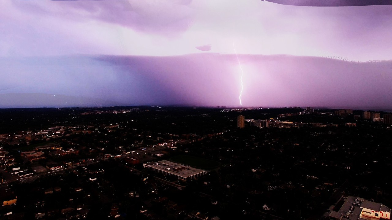
Lightning storm over Ottawa captured by high altitude drone
A drone launched high over Ottawa, capital of Canada, was sent up to monitor and record images of a severe approaching thunderstorm. The storm was the result of two converging low pressure fronts and a high pressure front. Winds were increasing rapidly and a heavy rain began to fall in the distance. The storm front was moving east and lightning was illuminating the evening sky.
As the storm approached, the drone hovered at 220m (660 feet). It recorded peals of thunder and cracks of lightning. The bolts could be seen arcing from the clouds to the ground and lighting up the horizon. After nearly twenty minutes of recording, the wind became very strong and the rain began to fall where the drone was located. It was brought back to earth as large drops pelted it and threatened to bring the drone crashing down. Even the strength of the wind made landing uncertain.
Thunder storms are one of nature's most spectacular shows. The awesome power unleashed by a lightning strike is greater than almost any force on earth. While we respect the destructive capabilities of storms like these, we can't help but admire the beauty and wonder of the spectacle.
Despite the fact that scientists have been studying lightning for hundreds of years, they still don't completely understand the entire process. Cloud to ground (CG) lightning is the most studied of the three types of lightning, due to the potential for damage and destruction on earth. Caused by the formation of an electrically conducting plasma channel between the cloud and the earth, at typical lightning bolt is over 5km (3 miles) in height. Lightning can also occur during hurricanes, dust storms and even forest fires, due to the rising columns of hot and cold air.
Whether you are a fan of summer thunder storms or not, you will almost certainly agree that they are spectacular and beautiful.
-
 2:34
2:34
WildCreatures
9 days ago $0.31 earnedHow you see your world is more important than you think
3.07K7 -
 0:26
0:26
ViralHog
4 years ago $0.91 earnedElectrical Storm Explodes With Intense Lightning
1.62K4 -
 0:13
0:13
ViralHog
4 years ago $0.28 earnedStorm Fills Sky With Spectacular Lightning
1.45K3 -
 0:15
0:15
ViralHog
4 years ago $2.11 earnedLightning Strike Scarily Close During Heavy Storm
3.47K3 -
 0:56
0:56
Kattjo24
4 years ago $6.48 earnedCrazy summer lightning storm is a wonder to behold
9.75K21 -
 0:37
0:37
Brandon
4 years agoCrazy lightning storm literally does not stop flashing in the sky
5.05K1 -
 0:19
0:19
ViralHog
3 years ago $0.58 earnedSecurity Camera Captures Lightning Striking House
2.43K1 -
 0:06
0:06
ViralHog
3 years ago $0.86 earnedStudents Scared by Close-by Lightning Strike
1.88K3 -
 0:12
0:12
ViralHog
3 years ago $13.85 earnedLightning strikes incredibly close to ferry in Sydney, Australia
102K83 -
 0:10
0:10
ViralHog
4 years ago $0.08 earnedHeart Shaped Lightning
683