Michael Fish's NBC26 Storm Shield weather forecast
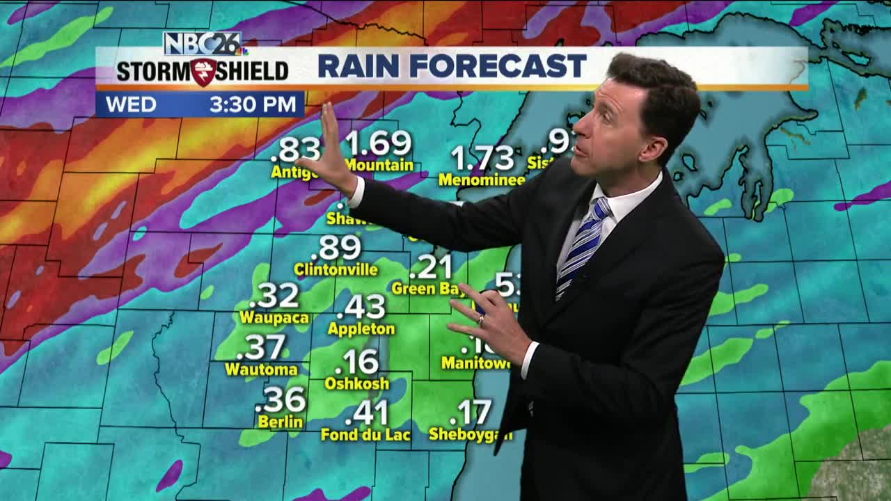
We have a warm front lifting its way north, and as it does so, it's going to take a lot of the rain with it. Though with sun coming back out at times and the heating of the day, there will be instability creeping up giving us a chance of a scattered afternoon shower or T'storm. Any storm that would pop could bring some gusty wind and downpours. Highs will be warm and muggy with readings in the low/mid-80s. This frontal boundary will now be pushing back south as a cold front tonight. This will bring us more rounds of showers and T'storms. Some of these could produce some locally heavy rainfall again, and it looks like the heaviest swath is going to set up to the northwest. Any storm this evening could bring some gusty wind or hail. Lows will be in the upper-60s. That frontal boundary will FINALLY be pushing through to the southeast as we head through Wednesday. We'll start off with rain & storms, but those should be tapering off from the northwest as we head through the day. Highs will only top out in the low/mid-70s. Pleasant weather returns for Thursday & Friday with highs in the low-70s. A few questions remain on whether we could see some weekend rain as the remnants of the tropical system Gordon will be ending up somewhere in the middle of the US.
-
 3:36
3:36
WGBA
1 year agoWill it be necessary to have both the AC & the heat on during the same day??
3801 -
 2:33
2:33
WGBA
4 years agoMichael Fish's NBC 26 weather forecast
4 -
 2:19
2:19
WGBA
4 years agoMichael Fish's NBC 26 weather forecast
3 -
 2:26
2:26
WGBA
4 years agoMichael Fish's NBC 26 weather forecast
4 -
 2:27
2:27
WGBA
4 years agoMichael Fish's NBC 26 weather forecast
4 -
 2:24
2:24
WGBA
4 years agoMichael Fish's NBC 26 weather forecast
3 -
 1:57
1:57
WGBA
4 years agoMichael Fish's NBC 26 weather forecast
2 -
 2:31
2:31
WGBA
4 years agoMichael Fish's NBC 26 weather forecast
7 -
 1:50
1:50
WGBA
4 years agoMichael Fish's NBC 26 weather forecast
4 -
 2:27
2:27
WGBA
4 years agoMichael Fish's NBC 26 weather forecast
1