NBC26 Storm Shield Weather Forecast
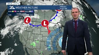
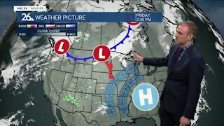
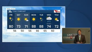
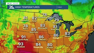
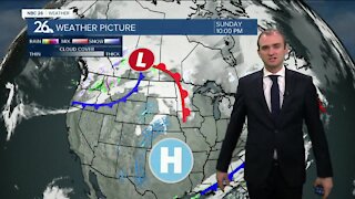
A relatively well-organized area of low pressure is heading our way today. This could touch off a couple scattered showers or a T'storm mainly this afternoon, but not everyone will see the rain. Highs will be in the upper-70s with cooler readings along Lake Michigan. Tonight, we'll see some scattered showers or a T'storm develop as the night wears on. The only question mark remains where the heaviest batch of rain will end up. The latest model guidance keeps the heaviest of the rain in southern Wisconsin, missing most of our area. Since it could move back north, Fond du Lac and Sheboygan counties remain under a Flash Flood Watch for this evening into tomorrow morning, though this area may get missed by the heaviest of the rainfall. Lows tonight will bottom out in the mid-60s. Tuesday, this system will be tracking away from the area, but on the backside of it, we still could see a hit or miss shower, or rumble of thunder. Highs will be cooler with readings in the mid-70s with breezy conditions. Tuesday night looks cooler and comfortable if you feel like cracking open your windows. Lows will bottom out in the low-50s. Wednesday looks like a beauty with sunshine and highs in the upper-70s.
-
 0:30
0:30
WGBA
7 months agoThree Degree Guarantee
61 -
 4:02
4:02
WGBA
3 years agoGino Recchia NBC26 Weather Forecast
8 -
 3:46
3:46
WGBA
3 years agoGino Recchia NBC26 Weather Forecast
15 -
 2:44
2:44
WGBA
3 years agoGino Recchia NBC26 Weather Forecast
5 -
 3:24
3:24
WGBA
3 years agoNBC26 Storm Shield Forecast
6 -
 3:24
3:24
WGBA
3 years agoNBC26 Storm Shield Forecast
8 -
 1:29
1:29
WGBA
3 years agoNBC26 Storm Shield Forecast
7 -
 3:12
3:12
WGBA
3 years agoGino Recchia NBC26 Weather Forecast
2 -
 4:48
4:48
WGBA
3 years agoGino Recchia NBC26 Weather Forecast
4 -
 2:08
2:08
WGBA
3 years agoGino Recchia NBC26 Weather Forecast
9