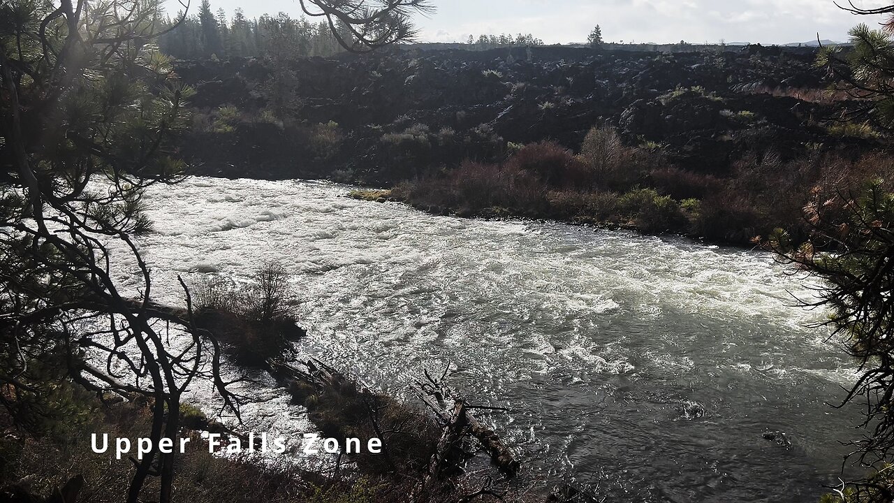
HIKING EXPLORING the Deschutes River Upper Falls Zone IN THE POURING RAIN! | Central Oregon | 4K
Chapters & Timestamps:
0:00 Arriving at the Edge of the EPIC Upper Falls Zone IN THE POURING RAIN!
0:24 Hiking Above the Upper Falls Area, a River Forest Volcanic Lava Rock Wonderland!
0:54 "Silent Perspectives" 4K Montage of 7 Unique Clips of Upper Falls & National Wild & Scenic Upper Deschutes River framed by Deschutes National Forest
In my opinion, there are about 8 Miles of PREMIUM River Shoreline Hiking on Deschutes River Trail along National Wild & Scenic Upper Deschutes River, Deschutes National Forest, Central Oregon.
This is EASILY a TOP 5 River Shoreline Hike in the Great State of Oregon! There are 3 Strategic Approaches to Capture/Tackle this EPIC area:
1) 8 Mile Point-to-Point Hike from Meadow Day Use Area to Sun-Lava Path Trailhead (called East Benham Falls Trailhead on Google Maps), in either Direction, need to arrange transportation at end of Hike!
2) 16 Mile Out & Back Hike from Meadow Day Use Area to Dillon Falls to Benham Falls to Sun-Lava Path Trailhead (called East Benham Falls Trailhead on Google Maps), in either Direction, no transportation logistics required, the Superstar Hiker Method!
3) Break Deschutes River Trail up into 2 separate more leisurely 8-Miles'ish Out & Back Hikes using Dillon Falls as the Midpoint:
a) Meadow Day Use Area Trailhead to Dillon Falls & Back.
b) Sun-Lava Path Trailhead (called East Benham Falls Trailhead on Google Maps) to Dillon Falls & Back.
On April 22, 2022, I Hiked 8 Miles Point-to-Point from Sun-Lava Path Trailhead (called East Benham Falls Trailhead on Google Maps) heading North to Benham Falls, Slough Day Use Area, Dillon Falls, Aspen Day Use Area, Big Eddy, Upper Falls, Lava Island Day Use Area, Lava Island to Meadow Day Use Area. It was a Low of 29F. Here is the FULL HIKE Video Link of that Hike:
On May 6, 2022, I Hiked 8 Miles Point-to-Point from Meadow Day Use Area Trailhead heading South to Lava Island, Lava Island Day Use Area, Upper Falls, Big Eddy, Aspen Day Use Area, Dillon Falls, Slough Day Use Area & Benham Falls to Sun-Lava Path Trailhead (called East Benham Falls Trailhead on Google Maps). It was a Low of 33F. There was a freak Hail Storm that added to the experience:
-
 16:30
16:30
HikingViking
1 month ago(4K UHD) REVIEWING EACH CAMPSITE @ East Shore Campground of Loon Lake! | BLM | Oregon Coast Range
69 -
![[GB]Long Stream?!?! ✨ Turtle Beach Partner !TB](https://1a-1791.com/video/fww1/20/s8/1/K/9/Z/5/K9Z5y.0kob-small-GBLong-Stream-Turtle-Beach-.jpg) LIVE
LIVE
OneRandomDolly
4 minutes ago[GB]Long Stream?!?! ✨ Turtle Beach Partner !TB
12 watching -
 20:33
20:33
Sideserf Cake Studio
1 day ago $0.71 earnedI Built A Bikini Bottom Fish Tank CAKE!
2.71K8 -
 LIVE
LIVE
Atarithepaladin
11 hours agoPaladin Playthrough Ep 17
12 watching -
 10:35
10:35
Warren Smith - Secret Scholar Society
1 day agoExposing the Illusion of Gary's Economics
41.1K8 -
 13:14
13:14
Michael Button
1 day ago $0.92 earnedThere’s a Giant Hole in Human History
3.24K9 -
 9:23
9:23
Russell Brand
20 hours agoThe TRUTH Behind Stephen Colbert's Downfall
44.4K72 -
 17:47
17:47
T-SPLY
1 day agoDems Fume: L.A Protesters Clash With Federal Agents And National Guard...Again!
3.77K12 -
 LIVE
LIVE
Lofi Girl
2 years agolofi hip hop radio 📚 - beats to relax/study to
514 watching -
 22:50
22:50
marcushouse
1 day ago $0.38 earnedStarship Tech Update Reveal, and Fire Time Already!? 🔥
3.47K5