HIKING EXPLORING the Deschutes River Upper Falls Zone IN THE POURING RAIN! | Central Oregon | 4K
Chapters & Timestamps:
0:00 Arriving at the Edge of the EPIC Upper Falls Zone IN THE POURING RAIN!
0:24 Hiking Above the Upper Falls Area, a River Forest Volcanic Lava Rock Wonderland!
0:54 "Silent Perspectives" 4K Montage of 7 Unique Clips of Upper Falls & National Wild & Scenic Upper Deschutes River framed by Deschutes National Forest
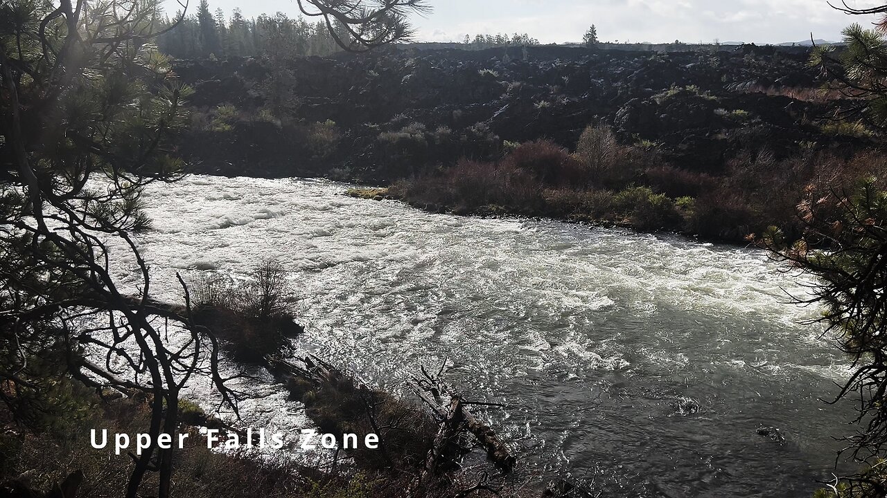
In my opinion, there are about 8 Miles of PREMIUM River Shoreline Hiking on Deschutes River Trail along National Wild & Scenic Upper Deschutes River, Deschutes National Forest, Central Oregon.
This is EASILY a TOP 5 River Shoreline Hike in the Great State of Oregon! There are 3 Strategic Approaches to Capture/Tackle this EPIC area:
1) 8 Mile Point-to-Point Hike from Meadow Day Use Area to Sun-Lava Path Trailhead (called East Benham Falls Trailhead on Google Maps), in either Direction, need to arrange transportation at end of Hike!
2) 16 Mile Out & Back Hike from Meadow Day Use Area to Dillon Falls to Benham Falls to Sun-Lava Path Trailhead (called East Benham Falls Trailhead on Google Maps), in either Direction, no transportation logistics required, the Superstar Hiker Method!
3) Break Deschutes River Trail up into 2 separate more leisurely 8-Miles'ish Out & Back Hikes using Dillon Falls as the Midpoint:
a) Meadow Day Use Area Trailhead to Dillon Falls & Back.
b) Sun-Lava Path Trailhead (called East Benham Falls Trailhead on Google Maps) to Dillon Falls & Back.
On April 22, 2022, I Hiked 8 Miles Point-to-Point from Sun-Lava Path Trailhead (called East Benham Falls Trailhead on Google Maps) heading North to Benham Falls, Slough Day Use Area, Dillon Falls, Aspen Day Use Area, Big Eddy, Upper Falls, Lava Island Day Use Area, Lava Island to Meadow Day Use Area. It was a Low of 29F. Here is the FULL HIKE Video Link of that Hike:
On May 6, 2022, I Hiked 8 Miles Point-to-Point from Meadow Day Use Area Trailhead heading South to Lava Island, Lava Island Day Use Area, Upper Falls, Big Eddy, Aspen Day Use Area, Dillon Falls, Slough Day Use Area & Benham Falls to Sun-Lava Path Trailhead (called East Benham Falls Trailhead on Google Maps). It was a Low of 33F. There was a freak Hail Storm that added to the experience:
-
 9:27
9:27
HikingViking
9 days ago(4K UHD) 3 LARGE GROUP CAMPSITES @ Horseshoe Cove Campground! | Baker Lake | Mt. Baker-Snoqualmie NF
391 -
 LIVE
LIVE
SavageJayGatsby
23 hours agoFirst Rumble Exclusive Stream?! | Let's Play: Prey | $300 Weekly Goal for Spicy Bite Saturday
114 watching -
 LIVE
LIVE
GritsGG
11 hours agoWin Streaking! Most Wins 3485+ 🧠
82 watching -
 LIVE
LIVE
Quite Frankly
6 hours ago"Mixed News, RFK Pull-up Challenge, Calls" ft. J Gulinello 8/28/25
517 watching -
 1:14:52
TheCrucible
3 hours agoThe Extravaganza! EP: 29 (8/28/25)
84.8K8 -
 1:09:58
Kim Iversen
4 hours agoTrans. Russian. Anti-Israel. Anti-Trump. Are You Buying This Story?
30.3K66 -
 1:51:08
Redacted News
4 hours agoEMERGENCY! BILL GATES CULT MEMBERS FOUND PLANTED INSIDE MULTIPLE FEDERAL AGENCIES, RFK FURIOUS
129K92 -
 31:02
31:02
Kimberly Guilfoyle
5 hours agoFull Breaking News Coverage: Live with John Nantz & Steve Moore | Ep250
28.6K13 -
 1:15:19
vivafrei
6 hours agoShameless Politicization of Tragedy! Susan Monarez is OUT! Pritzker is an IDIOT! & MORE!
130K50 -
 9:52
9:52
Tundra Tactical
3 hours agoCracker Meme Review On Tundra Meme Review!!
9.93K