Michael Fish's NBC26 Storm Shield weather forecast
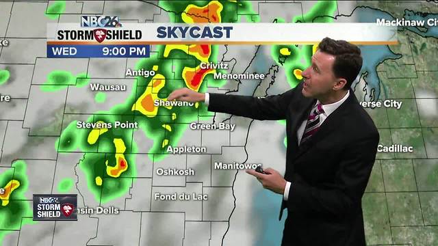
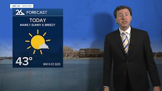
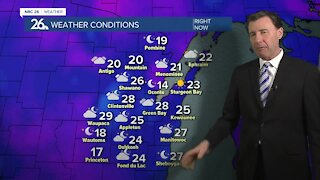
A cold front will be approaching the area later today into tonight. This will start to increase the chance of scattered T'storms as the day wears on from the northwest. The Storm Prediction Center has much of the area under a "Marginal Risk" of severe weather which means if you see a T'storm, there's a small chance it could bring you some gusty wind or hail. This front will be pushing through the area as the night wears on bringing the area some scattered showers or T'storms. As the sun goes down, so will the risk of possibly seeing some gusty wind or hail out of any shower or T'storm moving through. Overnight lows will bottom out around 60. Thursday, that cold front will live up to its name bringing us cooler weather. We'll only have high temperatures topping out in the low-70s with even cooler readings near Lake Michigan. There will be a small chance of a shower as the day wears on, but it won't be a wash. Thursday night should become mostly clear and comfortable with lows in the low- to mid-50s. Friday looks dry with highs around 80. Warm, humid air returns for the weekend, highs topping off in the upper-80s both Saturday and Sunday. A risk of showers and storms comes back Sunday and Monday.
-
 1:57
1:57
WGBA
1 year agoHow the City of Green Bay is hoping a $1.6M investment will make the community safer for pedestrians
4742 -
 2:33
2:33
WGBA
4 years agoMichael Fish's NBC 26 weather forecast
4 -
 2:19
2:19
WGBA
4 years agoMichael Fish's NBC 26 weather forecast
3 -
 2:26
2:26
WGBA
4 years agoMichael Fish's NBC 26 weather forecast
4 -
 2:27
2:27
WGBA
4 years agoMichael Fish's NBC 26 weather forecast
4 -
 2:24
2:24
WGBA
4 years agoMichael Fish's NBC 26 weather forecast
3 -
 1:57
1:57
WGBA
4 years agoMichael Fish's NBC 26 weather forecast
2 -
 2:31
2:31
WGBA
4 years agoMichael Fish's NBC 26 weather forecast
7 -
 1:50
1:50
WGBA
4 years agoMichael Fish's NBC 26 weather forecast
4 -
 2:27
2:27
WGBA
4 years agoMichael Fish's NBC 26 weather forecast
1